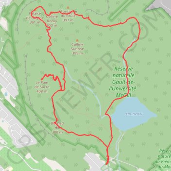
Randonnée au Centre de la Nature Mont Saint-Hilaire
Randonnée en boucle depuis Mont-Saint-Hilaire. #Randonnée #Boucle
- Distance: 7.4 mi
- Elevation gain: 1,578 ft
- Maximum elevation: 1,286 ft
- Elevation loss: 1,578 ft
- Minimum elevation: 436 ft
- Moving time: 3 h 2 m
- Moving speed: 2.4 mph
- Maximum speed: 12.0 mph
- Total time: 4 h 3 m
- Global speed: 1.8 mph
- Date: 03/27/2011
Interactive map
GPS track profile
About this GPS track
Name: Randonnée au Centre de la Nature Mont Saint-Hilaire GPS track, route, trail
Coordinates: 45.53656 -73.17486 45.56230 -73.14955
Other GPS tracks
Click on a GPS track to view route, its statistics and profile.
Randonnée au Centre de la Nature Mont Saint-Hilaire
Canada > Québec > La Vallée-du-Richelieu > Mont-Saint-Hilaire
Distance: 7.4 mi • Elevation gain: 1,568 ft • Maximum elevation: 1,286 ft
Pierreville - Leclercville
Canada > Quebec > Urban agglomeration of Montreal > Montreal
#Bike #Pierreville #Leclercville #Atlantic
Distance: 75.1 mi • Elevation gain: 1,063 ft • Maximum elevation: 118 ft