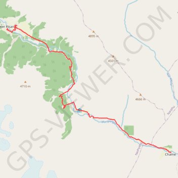
Tour Annapurna - Jour 05 - Chame - Pisang
Randonnée entre Chame et Pisang. #Randonnée
- Distance: 12.2 mi
- Elevation gain: 6,939 ft
- Maximum elevation: 11,227 ft
- Elevation loss: 5,259 ft
- Minimum elevation: 8,809 ft
Interactive map
GPS track profile
About this GPS track
Name: Tour Annapurna - Jour 05 - Chame - Pisang GPS track, route, trail
Start: Besishahar - Manang Sadak (Jeep Road), Chame-04, Chame, मनाङ, Gandaki, Népal (28.55150 84.24284)
Coordinates: 28.55150 84.14794 28.61605 84.24284
Other GPS tracks
Click on a GPS track to view route, its statistics and profile.
Annapurna - Example
Népal > Gandaki > मनाङ > Dharapani
Distance: 104.2 mi • Elevation gain: 40,039 ft • Maximum elevation: 19,751 ft