GPS tracks, routes, trails, hikes

GPS tracks visualization and sharing, free and without registration.

Import a GPX file

Tour Annapurna - Jour 04 - Dharapani - Chame

Randonnée entre Dharapani et Chame. #Randonnée
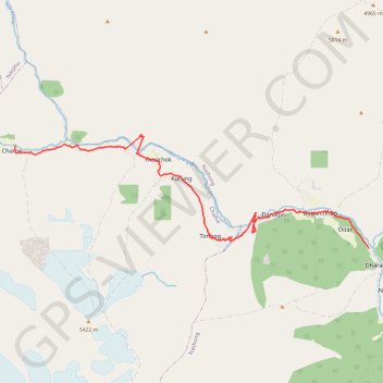
  • Distance: 12.8 mi
  • Elevation gain: 6,644 ft
  • Maximum elevation: 9,012 ft
  • Elevation loss: 4,137 ft
  • Minimum elevation: 6,325 ft

Interactive map

GPS track profile

About this GPS track

Name: Tour Annapurna - Jour 04 - Dharapani - Chame GPS track, route, trail.
Start: Check Point, Besishahar - Manang Sadak (Jeep Road), Nache, Dharapani, Nashong, मनाङ, Gandaki Pradesh, Népal (28.52367 84.35493)
End: Hotel Marshyangdi Mandala, Besishahar - Manang Sadak (Jeep Road), Chame, मनाङ, Gandaki Pradesh, Népal (28.55191 84.24366)
Coordinates: 28.52367 84.24325 28.55501 84.35493

Other GPS tracks

Tour Annapurna - Jour 03 - Jagat - Dharapani

Népal > लमजुङ > Ghermu

Randonnée pédestre. Entre Jagat et Dharapani. #Randonnée

Distance: 15.2 mi - Elevation gain: 11,480 ft - Maximum elevation: 6,841 ft - Coordinates: 28.41737 84.35421 28.52420 84.40472

Start: Besishahar - Manang Sadak (Jeep Road), Ghermu, Marsyangdi, लमजुङ, Gandaki Pradesh, Népal (28.41737 84.40472)

End: Besishahar - Manang Sadak (Jeep Road), Nache, Dharapani, Nashong, मनाङ, Gandaki Pradesh, Népal (28.51762 84.35818)

Annapurna - Example

Népal > मनाङ > Nache

Distance: 104.2 mi - Elevation gain: 41,230 ft - Maximum elevation: 19,701 ft - Coordinates: 28.51753 83.58368 28.79903 84.35875

Start: Tashi Delek Hotel, Besishahar - Manang Sadak (Jeep Road), Nache, Dharapani, Nashong, मनाङ, Gandaki, Népal (28.51753 84.35875)

End: Lomanthang Guest House, Road Beni - Jomsom, Marpha, Gharapjhong, मुस्ताङ, Gandaki, Népal (28.78236 83.72345)

Jagat à Dahrapani

Népal > लमजुङ > Ghermu

Randonnée pédestre. Entre Jagat et Dharapani. #Randonnée

Distance: 20.0 mi - Elevation gain: 15,988 ft - Maximum elevation: 6,919 ft - Coordinates: 28.41737 84.35421 28.52420 84.40472

Start: Besishahar - Manang Sadak (Jeep Road), Ghermu, Marsyangdi, लमजुङ, Gandaki Pradesh, Népal (28.41737 84.40472)

End: Besishahar - Manang Sadak (Jeep Road), Nache, Dharapani, Nashong, मनाङ, Gandaki Pradesh, Népal (28.51762 84.35818)

Dharapani Ascension

Népal > मनाङ > Nache

Distance: 5.2 mi - Elevation gain: 2,848 ft - Maximum elevation: 7,589 ft - Total time: 2 h 16 m - Date: 10/02/2021 - Coordinates: 28.52046 84.34943 28.54616 84.38233

Start: Hotel, Besishahar - Manang Sadak (Jeep Road), Nache, Dharapani, Nashong, मनाङ, Gandaki Pradesh, Népal (28.52058 84.35751)

End: the north face, Manaslu Circuit, Tilche, Thoche, Nashong, मनाङ, Gandaki Pradesh, Népal (28.54605 84.38187)