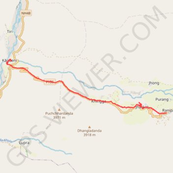
Tour Annapurna - Jour 11 - Muktinath - Kagbeni
Randonnée pédestre. Entre Ranipauwa et Kagbeni. #Randonnée
- Distance: 7.3 mi
- Elevation gain: 302 ft
- Maximum elevation: 12,034 ft
- Elevation loss: 3,018 ft
- Minimum elevation: 9,308 ft
- Moving time: 3 h 23 m
- Moving speed: 2.2 mph
- Maximum speed: 8.6 mph
- Total time: 5 h 33 m
- Global speed: 1.3 mph
- Date: 04/10/2014
Interactive map
GPS track profile
About this GPS track
Name: Tour Annapurna - Jour 11 - Muktinath - Kagbeni GPS track, route, trail
Coordinates: 28.81457 83.78294 28.83820 83.86179
Other GPS tracks
Click on a GPS track to view route, its statistics and profile.
Tour Annapurna - Jour 12 - Kagbeni - Marpha
Népal > Gandaki > मुस्ताङ > Ekle Bhatti
Randonnée entre Kagbeni et Jomsom. #Randonnée
Distance: 10.7 mi • Elevation gain: 1,175 ft • Maximum elevation: 9,383 ft