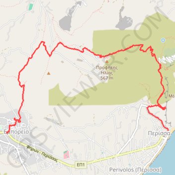
Profitis Ilias de Santorin
Randonnée entre Emporio et Perissa. #Randonnée
- Distance: 4.9 mi
- Elevation gain: 1,873 ft
- Maximum elevation: 1,808 ft
- Elevation loss: 2,119 ft
- Minimum elevation: -3 ft
- Moving time: 2 h 42 m
- Moving speed: 1.8 mph
- Maximum speed: 6.7 mph
- Total time: 3 h 27 m
- Global speed: 1.4 mph
- Date: 07/11/2013
Interactive map
GPS track profile
About this GPS track
Name: Profitis Ilias de Santorin GPS track, route, trail
Coordinates: 36.35681 25.44430 36.37114 25.47574
Other GPS tracks
Click on a GPS track to view route, its statistics and profile.
Profitis Ilias de Santorin
Greece > Aegean > Thira Regional Unit > Thira Municipal Unit > Emporio
Distance: 4.8 mi • Elevation gain: 1,749 ft • Maximum elevation: 1,804 ft