Preuswald gemmenich
Interactive map
GPS track profile
About this GPS track
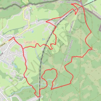
Name: Preuswald gemmenich GPS track, route, trail
Coordinates: 50.73266 5.99492 50.75397 6.02505
Other GPS tracks
Click on a GPS track to view route, its statistics and profile.
Tour d'Europe
France > Bretagne > Finistère > Concarneau > Landan Creis
Distance: 4,432.2 mi • Elevation gain: 146,335 ft • Maximum elevation: 7,982 ft
Eurovelo 15 - Entire Route
Pays-Bas > Hollande-Méridionale > Hoek van Holland
Distance: 903.2 mi • Elevation gain: 27,156 ft • Maximum elevation: 6,716 ft
Rhin par la rive gauche
Suisse > Uri > Korporation Ursern > Andermatt
Vélo. En aller simple entre Andermatt et Hoek van Holland. Suisse centrale. #Vélo #SuisseCentrale #Alpes #Montagne #Nature
Distance: 903.8 mi • Elevation gain: 22,533 ft • Maximum elevation: 6,716 ft
Stage 14: Frederikshavn to Aars — European Divide Trail
Danemark > Jutland du Nord > Frederikshavn
Distance: 1,382.7 mi • Elevation gain: 94,114 ft • Maximum elevation: 4,557 ft
Rhin par la rive gauche
Suisse > Uri > Korporation Ursern > Andermatt
Distance: 903.6 mi • Elevation gain: 20,518 ft • Maximum elevation: 6,726 ft
Eurovelo 15 - Strasbourg Rotterdam
France > Grand Est > Bas-Rhin > Strasbourg
comment ...
Distance: 554.1 mi • Elevation gain: 7,021 ft • Maximum elevation: 479 ft
Eurovéloroute-15-Route-du-Rhin
Suisse > Uri > Korporation Ursern > Andermatt
Distance: 931.4 mi • Elevation gain: 22,854 ft • Maximum elevation: 6,713 ft
GR128 De Maastricht (Pays-Bas) à Aachen (Allemagne)
Pays-Bas > Limbourg > Maastricht
Randonnée entre Maastricht et Aachen. #Randonnée
Distance: 33.9 mi • Elevation gain: 3,110 ft • Maximum elevation: 1,125 ft
Eurovelo 15 - Entire Route
Pays-Bas > Hollande-Méridionale > Hoek van Holland
Distance: 903.5 mi • Elevation gain: 25,433 ft • Maximum elevation: 6,726 ft
Blegny - Eynatten
Belgique > Liège > Verviers > Raeren
Distance: 40.0 mi • Elevation gain: 3,484 ft • Maximum elevation: 1,129 ft
Marche-en-Famenne
Belgique > Luxembourg > Marche-en-Famenne > Marche-en-Famenne
<p>From Rue Dupont 46, 6900 Marche-en-Famenne, Belgium<br/> To Avenue de France, 6900 Marche-en-Famenne, Belgium</p> <p>Routing Motor - nicest</p>
Distance: 1,766.8 mi • Elevation gain: 94,672 ft • Maximum elevation: 3,537 ft
Eurovelo 15 - Strasbourg Rotterdam
France > Grand Est > Bas-Rhin > Strasbourg
Distance: 554.1 mi • Elevation gain: 6,903 ft • Maximum elevation: 479 ft
Eurovelo 15 - Entire Route
Pays-Bas > Hollande-Méridionale > Hoek van Holland
Distance: 903.5 mi • Elevation gain: 25,433 ft • Maximum elevation: 6,726 ft
De Guirsch à Gendron (définitif) J1
Belgique > Luxembourg > Arlon > Arlon > Guirsch
Distance: 628.8 mi • Elevation gain: 40,561 ft • Maximum elevation: 2,277 ft
De Guirsch à Gendron
Belgique > Luxembourg > Arlon > Arlon > Guirsch
Distance: 613.6 mi • Elevation gain: 41,873 ft • Maximum elevation: 2,277 ft
Chenestre ⇄ Vijlen
Belgique > Liège > Liège > Chenestre
Distance: 48.5 mi • Elevation gain: 3,258 ft • Maximum elevation: 928 ft
GR005_Parcours-principal_2021-05-06
Netherlands > Limburg > Maastricht
GR005_Parcours-principal_2021-05-06
Distance: 205.8 mi • Elevation gain: 29,472 ft • Maximum elevation: 1,877 ft
240 KM 2022
Netherlands > Limburg > Valkenburg
Distance: 150.2 mi • Elevation gain: 9,311 ft • Maximum elevation: 1,076 ft
Jour 19 / 28 Juin 2022 (Final)
Distance: 548.6 mi • Elevation gain: 26,273 ft • Maximum elevation: 3,123 ft
Riethoven naar Oostenrijk
Netherlands > North Brabant > Riethoven > Eind
Distance: 573.0 mi • Elevation gain: 44,715 ft • Maximum elevation: 6,224 ft
Pepinster to Trooz
Belgique > Liège > Verviers > Cornesse
Distance: 72.2 mi • Elevation gain: 2,904 ft • Maximum elevation: 1,007 ft