Codosera
Interactive map
GPS track profile
About this GPS track
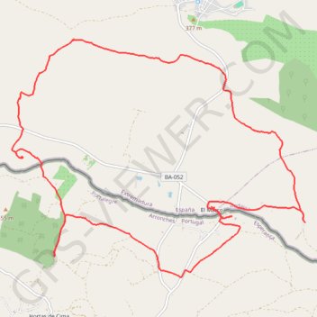
Name: Codosera GPS track, route, trail
Coordinates: 39.17322 -7.20178 39.20161 -7.15662
Other GPS tracks
Click on a GPS track to view route, its statistics and profile.
EuroVelo 1 (Spain)
Espagne > Andalousie > Côte occidentale > Ayamonte
Distance: 842.4 mi • Elevation gain: 47,858 ft • Maximum elevation: 4,331 ft
Eurovelo 01 Spain + Portugal
France > Nouvelle-Aquitaine > Pyrénées-Atlantiques > Hendaye
Distance: 1,930.7 mi • Elevation gain: 100,367 ft • Maximum elevation: 4,931 ft
Southern section — European Divide Trail
France > Auvergne-Rhône-Alpes > Drôme > Valence
Distance: 1,506.1 mi • Elevation gain: 139,026 ft • Maximum elevation: 6,578 ft
Stage 26: Valence to Saint-Jean-de-Fos — European Divide Trail
France > Auvergne-Rhône-Alpes > Drôme > Valence
Distance: 1,506.1 mi • Elevation gain: 139,026 ft • Maximum elevation: 6,578 ft
EuroVelo 1 (Spain)
Espagne > Andalousie > Côte occidentale > Ayamonte > Pozo del Camino > Fotea
Distance: 838.7 mi • Elevation gain: 44,754 ft • Maximum elevation: 4,331 ft
LLOR2022_Final_10K_CP
Portugal > Faro > Vila Real de Santo António > Monte Gordo
Distance: 587.8 mi • Elevation gain: 66,362 ft • Maximum elevation: 3,707 ft
Esperança
Portugal > Portalegre > Esperança
Randonnée pédestre. Depuis Esperança. #Randonnée
Distance: 15.5 mi • Elevation gain: 1,342 ft • Maximum elevation: 1,450 ft