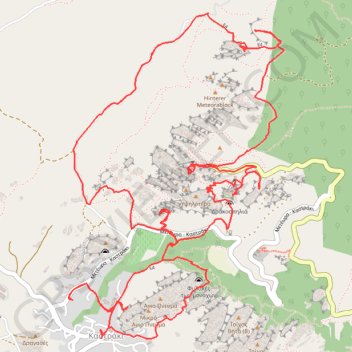
Le tour des météores
Interactive map
GPS track profile
About this GPS track
Name: Le tour des météores GPS track, route, trail
Coordinates: 39.71661 21.61775 39.73545 21.63402
Other GPS tracks
Click on a GPS track to view route, its statistics and profile.
Le tour des météores
Grèce > Thessalie-Grèce centrale > Περιφερειακή Ενότητα Τρικάλων > Kastraki
Distance: 8.7 mi • Elevation gain: 2,717 ft • Maximum elevation: 1,893 ft