Coma-ruga - Barranc del Lleó
Interactive map
GPS track profile
About this GPS track
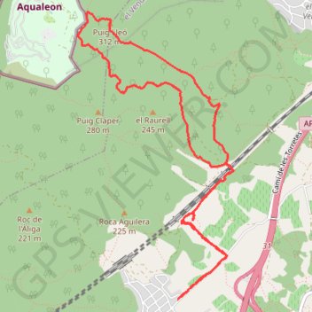
Name: Coma-ruga - Barranc del Lleó GPS track, route, trail
Coordinates: 41.20580 1.49126 41.22931 1.50812
Other GPS tracks
Click on a GPS track to view route, its statistics and profile.
Southern section — European Divide Trail
France > Auvergne-Rhône-Alpes > Drôme > Valence
Distance: 1,506.1 mi • Elevation gain: 139,026 ft • Maximum elevation: 6,578 ft
1 LUCENA - MONTPELLIER
Distance: 1,842.0 mi • Elevation gain: 96,785 ft • Maximum elevation: 3,438 ft
1 LUCENA - MONTPELLIER
Espagne > Andalousie > Lucena
Distance: 1,842.0 mi • Elevation gain: 96,785 ft • Maximum elevation: 3,438 ft
Stage 26: Valence to Saint-Jean-de-Fos — European Divide Trail
France > Auvergne-Rhône-Alpes > Drôme > Valence
Distance: 1,506.1 mi • Elevation gain: 139,026 ft • Maximum elevation: 6,578 ft
Stage 26: Valence to Saint-Jean-de-Fos — European Divide Trail
France > Auvergne-Rhône-Alpes > Drôme > Valence
Distance: 1,012.7 mi • Elevation gain: 101,184 ft • Maximum elevation: 6,578 ft
Monday Afternoon Flight
Espagne > Îles Baléares > Palma > Son Banya
Distance: 391.4 mi • Elevation gain: 87,385 ft • Maximum elevation: 8,478 ft
Santa Susana, Cardedeu, Castellbell i Vilar, Prades, Torto
Espagne > Catalogne > Maresme > Santa Susanna
Distance: 252.4 mi • Elevation gain: 40,023 ft • Maximum elevation: 3,770 ft