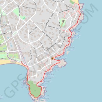
Cami de ronda à S'AGARO Catalogne sud
Randonnée entre Sant Feliu de Guíxols et S'Agaró. #Randonnée
- Distance: 1.3 mi
- Elevation gain: 184 ft
- Maximum elevation: 69 ft
- Elevation loss: 184 ft
- Minimum elevation: 0 ft
- Moving time: 46 m 22 s
- Moving speed: 1.7 mph
- Maximum speed: 5.2 mph
- Total time: 1 h 5 s
- Global speed: 1.3 mph
- Date: 04/05/2015
Interactive map
GPS track profile
About this GPS track
Name: Cami de ronda à S'AGARO Catalogne sud GPS track, route, trail
Coordinates: 41.78745 3.05344 41.79658 3.06112
Other GPS tracks
Click on a GPS track to view route, its statistics and profile.
1 LUCENA - MONTPELLIER
Espagne > Andalousie > Lucena
Distance: 1,842.0 mi • Elevation gain: 96,785 ft • Maximum elevation: 3,438 ft
1 LUCENA - MONTPELLIER
Distance: 1,842.0 mi • Elevation gain: 96,785 ft • Maximum elevation: 3,438 ft
Southern section — European Divide Trail
France > Auvergne-Rhône-Alpes > Drôme > Valence
Distance: 1,506.1 mi • Elevation gain: 139,026 ft • Maximum elevation: 6,578 ft
Stage 26: Valence to Saint-Jean-de-Fos — European Divide Trail
France > Auvergne-Rhône-Alpes > Drôme > Valence
Distance: 1,506.1 mi • Elevation gain: 139,026 ft • Maximum elevation: 6,578 ft
ES-mapa-cami-ronda
Espagne > Catalogne > Bas-Ampurdan > Begur
Distance: 26.5 mi • Elevation gain: 4,134 ft • Maximum elevation: 719 ft
Lloret- la Bisbal- Sant Garu- Lloret
Espagne > la Selva > Lloret de Mar
Distance: 82.2 mi • Elevation gain: 10,486 ft • Maximum elevation: 1,545 ft
Barcelonne
Espagne > Haut-Ampurdan > Llançà
Barcelonne
Distance: 824.8 mi • Elevation gain: 102,241 ft • Maximum elevation: 5,692 ft
Stage 26: Valence to Saint-Jean-de-Fos — European Divide Trail
France > Auvergne-Rhône-Alpes > Drôme > Valence
Distance: 1,012.7 mi • Elevation gain: 101,184 ft • Maximum elevation: 6,578 ft
OziCE Track Log File- filtered
France > Occitanie > Pyrénées-Orientales > Banyuls-sur-Mer
OziCE Track Log File- filtered
Distance: 907.8 mi • Elevation gain: 118,281 ft • Maximum elevation: 5,715 ft