Callanques Ferriol et Pedrosa
Randonnée en boucle depuis Torroella de Montgrí. #Randonnée #Boucle
- Distance: 5.5 mi
- Elevation gain: 1,532 ft
- Maximum elevation: 548 ft
- Elevation loss: 1,490 ft
- Minimum elevation: 13 ft
- Moving time: 3 h 8 m
- Moving speed: 1.8 mph
- Maximum speed: 3.2 mph
- Total time: 5 h 20 m
- Global speed: 1.0 mph
- Date: 07/13/2012
Interactive map
GPS track profile
About this GPS track
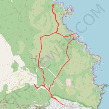
Name: Callanques Ferriol et Pedrosa GPS track, route, trail
Coordinates: 42.05570 3.18813 42.08313 3.20273
Other GPS tracks
Click on a GPS track to view route, its statistics and profile.
Southern section — European Divide Trail
France > Auvergne-Rhône-Alpes > Drôme > Valence
Distance: 1,506.1 mi • Elevation gain: 139,026 ft • Maximum elevation: 6,578 ft
1 LUCENA - MONTPELLIER
Espagne > Andalousie > Lucena
Distance: 1,842.0 mi • Elevation gain: 96,785 ft • Maximum elevation: 3,438 ft
1 LUCENA - MONTPELLIER
Distance: 1,842.0 mi • Elevation gain: 96,785 ft • Maximum elevation: 3,438 ft
Stage 26: Valence to Saint-Jean-de-Fos — European Divide Trail
France > Auvergne-Rhône-Alpes > Drôme > Valence
Distance: 1,506.1 mi • Elevation gain: 139,026 ft • Maximum elevation: 6,578 ft
Barcelonne
Espagne > Haut-Ampurdan > Llançà
Barcelonne
Distance: 824.8 mi • Elevation gain: 102,241 ft • Maximum elevation: 5,692 ft
Callanques Ferriol et Pedrosa
Espagne > Catalogne > Bas-Ampurdan > Torroella de Montgrí
Distance: 5.5 mi • Elevation gain: 1,532 ft • Maximum elevation: 548 ft
Stage 26: Valence to Saint-Jean-de-Fos — European Divide Trail
France > Auvergne-Rhône-Alpes > Drôme > Valence
Distance: 1,012.7 mi • Elevation gain: 101,184 ft • Maximum elevation: 6,578 ft
OziCE Track Log File- filtered
France > Occitanie > Pyrénées-Orientales > Banyuls-sur-Mer
OziCE Track Log File- filtered
Distance: 907.8 mi • Elevation gain: 118,281 ft • Maximum elevation: 5,715 ft