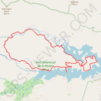
Raid La Pérignon - Parc Provincial de La Rivière Bleue
Interactive map
GPS track profile
About this GPS track
Name: Raid La Pérignon - Parc Provincial de La Rivière Bleue GPS track, route, trail
Start: Piste Pérignon, Yaté, Province Sud, Nouvelle-Calédonie, 98834, France (-22.12847 166.70309)
End: Piste Pérignon, Yaté, Province Sud, Nouvelle-Calédonie, 98834, France (-22.12861 166.70305)
Coordinates: -22.12872 166.64955 -22.09505 166.72910
Other GPS tracks
Click on a GPS track to view route, its statistics and profile.
Raid La Pérignon - Parc Provincial de La Rivière Bleue
France > Province Sud > Yaté
Distance: 16.8 mi • Elevation gain: 1,322 ft • Maximum elevation: 876 ft