Rando des Caps - Flamanville
Interactive map
GPS track profile
About this GPS track
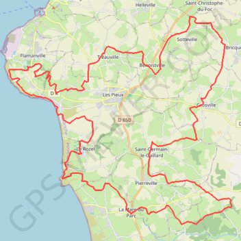
Name: Rando des Caps - Flamanville GPS track, route, trail
Coordinates: 49.45321 -1.88291 49.55014 -1.72250
Other GPS tracks
Click on a GPS track to view route, its statistics and profile.
Tour d'Europe
France > Bretagne > Finistère > Concarneau > Landan Creis
Distance: 4,432.2 mi • Elevation gain: 146,335 ft • Maximum elevation: 7,982 ft
Sentier Cotentin - Cherbourg vers Mont-Saint-Michel
France > Normandie > Manche > La Hague > Urville-Nacqueville > La Rivière
Distance: 144.0 mi • Elevation gain: 8,478 ft • Maximum elevation: 420 ft
GR 223 Tour du Cotentin (2021)
France > Normandie > Eure > Berville-sur-Mer
Randonnée en Normandie sur le GR 223 autour du Cotentin à travers l'Eure, le Calvados et la Manche de Berville-sur-Mer au Mont-Saint-Michel.
Distance: 404.3 mi • Elevation gain: 21,932 ft • Maximum elevation: 489 ft
2 - 26km_trail_de_tcheu_nous_2024-18611297-1711391976-647
France > Normandie > Manche > Les Pieux > Hameau Courtois
Trail 26 km
Distance: 16.0 mi • Elevation gain: 2,100 ft • Maximum elevation: 417 ft
1 - 8km_trail_marche_2023-16094180-1678826890-97
France > Normandie > Manche > Les Pieux > Hameau Courtois
Trail et marche 8 km
Distance: 4.2 mi • Elevation gain: 404 ft • Maximum elevation: 348 ft
3 - marche_13km_2023-16094307-1678826875-803
France > Normandie > Manche > Les Pieux > Hameau Courtois
Marche 13 km
Distance: 6.7 mi • Elevation gain: 804 ft • Maximum elevation: 417 ft
4 - trail_13km_2023-16094512-1678826861-849
France > Normandie > Manche > Les Pieux > Hameau Courtois
Trail 13 km
Distance: 7.7 mi • Elevation gain: 1,135 ft • Maximum elevation: 417 ft
GR22 - De Cherbourg à Flamanville
France > Normandie > Manche > Cherbourg-en-Cotentin
Randonnée entre Cherbourg-Octeville et Flamanville. #Randonnée
Distance: 43.6 mi • Elevation gain: 4,846 ft • Maximum elevation: 430 ft
GR223 - Cherbourg à Coutances
France > Normandie > Manche > Cherbourg-en-Cotentin
Randonnée entre Cherbourg-Octeville et Coutances. #Randonnée
Distance: 125.1 mi • Elevation gain: 6,909 ft • Maximum elevation: 453 ft
RAF 2022 / 2600 n1 News
France > Hauts-de-France > Pas-de-Calais > Le Touquet-Paris-Plage
Distance: 1,612.3 mi • Elevation gain: 130,331 ft • Maximum elevation: 9,075 ft
Rando cap de la Hague
France > Normandie > Manche > La Hague > Urville-Nacqueville > La Rivière
Randonnée entre Urville-Nacqueville et Baubigny. #Randonnée
Distance: 49.6 mi • Elevation gain: 4,521 ft • Maximum elevation: 427 ft
Itinéraire de Nemours à Nemours
France > Centre-Val de Loire > Loiret > Bromeilles > Bainvilliers
Distance: 979.5 mi • Elevation gain: 28,005 ft • Maximum elevation: 781 ft
Randonnée de Cherbourg à Portbail par le GR 223
France > Normandie > Manche > Cherbourg-en-Cotentin
Randonnée sur sentier du littoral à travers la Manche de Cherbourg à Portbail via Equeurdreville, Urville-Nacqueville, Hameau aux Fèvres (Greville-Hague), Digulleville, Herqueville, Biville, Les Pieux, Surtainville, Baubigny, Barneville-Carteret et Barneville-Carteret. #Randonnée #GR223 #Normandie #Manche #Mer #Nature
Distance: 68.7 mi • Elevation gain: 6,890 ft • Maximum elevation: 430 ft
Randonnée Biville
France > Normandie > Manche > La Hague > Auderville
Randonnée entre Auderville et Les Pieux. #Randonnée
Distance: 28.4 mi • Elevation gain: 5,344 ft • Maximum elevation: 423 ft
TM2024 ET2 Barneville- Sartilly V1-17625469
France > Normandie > Manche > Barneville-Carteret > Le Dessous du Bourg
Distance: 106.1 mi • Elevation gain: 5,656 ft • Maximum elevation: 427 ft
GR223 De Tourlaville à Portbail (Manche)
France > Normandie > Manche > Cherbourg-en-Cotentin
Randonnée entre Cherbourg-Octeville et Portbail. #Randonnée
Distance: 68.5 mi • Elevation gain: 6,647 ft • Maximum elevation: 430 ft
TM2024 ET2 Barneville- Sartilly V1-17625469
France > Normandie > Manche > Barneville-Carteret > Le Dessous du Bourg
Distance: 106.1 mi • Elevation gain: 5,656 ft • Maximum elevation: 427 ft
TM2024 ET2 Barneville - Sartilly V2-17230687
France > Normandie > Manche > Barneville-Carteret > Le Dessous du Bourg
Distance: 98.3 mi • Elevation gain: 4,977 ft • Maximum elevation: 427 ft
Flamanville (Rando des caps 2022) 56km
France > Normandie > Manche > Flamanville > Marcanville
Distance: 35.2 mi • Elevation gain: 3,212 ft • Maximum elevation: 463 ft