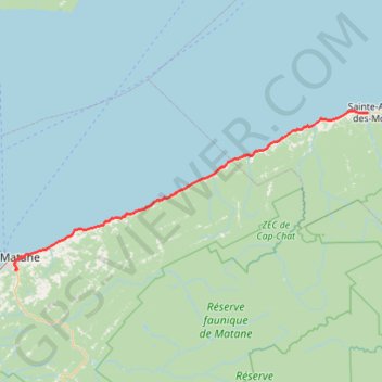
Matane - Sainte-Anne-des-Monts
Saint Lawrence River. #Bike #Matane #SainteAnneDesMonts #SaintLawrence
- Distance: 55.2 mi
- Elevation gain: 2,585 ft
- Maximum elevation: 295 ft
- Elevation loss: 2,631 ft
- Minimum elevation: 0 ft
Interactive map
GPS track profile
About this GPS track
Name: Matane - Sainte-Anne-des-Monts GPS track, route, trail
Coordinates: 48.82088 -67.54630 49.12713 -66.51072
Other GPS tracks
Click on a GPS track to view route, its statistics and profile.
La Traversée des Chic-Chocs
Canada > Québec > La Matanie > Rivière-Bonjour
Randonnée entre Les Méchins et Cap-au-Renard. #Randonnée
Distance: 59.7 mi • Elevation gain: 15,509 ft • Maximum elevation: 3,724 ft
Rimouski - Matane
Canada > Quebec > Rimouski-Neigette > Rimouski > L'Anse-au-Sable
Saint Lawrence River. #Bike #Rimouski #Matane #SaintLawrence
Distance: 64.9 mi • Elevation gain: 1,591 ft • Maximum elevation: 190 ft
Sainte-Anne-des-Monts - Madeleine
Canada > Quebec > La Haute-Gaspésie > Sainte-Anne-des-Monts
Saint Lawrence River. #Bike #SainteAnneDesMonts #Madeleine #SaintLawrence
Distance: 57.5 mi • Elevation gain: 2,841 ft • Maximum elevation: 351 ft