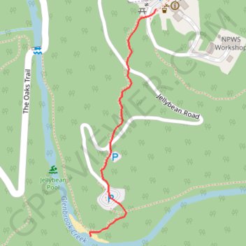
Jellybean Pool
Blue Mountains National Park. #Hike #BlueMountains
- Distance: 0.3 mi
- Elevation gain: 0 ft
- Maximum elevation: 469 ft
- Elevation loss: 233 ft
- Minimum elevation: 233 ft
- Moving time: 8 m 17 s
- Moving speed: 2.1 mph
- Maximum speed: 3.8 mph
- Total time: 8 m 17 s
- Global speed: 2.1 mph
- Date: 01/17/2020
Interactive map
GPS track profile
About this GPS track
Name: Jellybean Pool GPS track, route, trail
Coordinates: -33.78174 150.61937 -33.77846 150.62052
Other GPS tracks
Click on a GPS track to view route, its statistics and profile.
Bennetts Ridge Loop
Australia > New South Wales > Sydney > Glenbrook
Blue Mountains National Park. #Hike #MTB #Loop #BlueMountains
Distance: 8.9 mi • Elevation gain: 1,053 ft • Maximum elevation: 722 ft
Woodford - Glenbrook
Australia > New South Wales > Sydney > Woodford
Oaks Fire Trail. Blue Mountains National Park. #MTB #BlueMountains
Distance: 16.8 mi • Elevation gain: 1,342 ft • Maximum elevation: 1,988 ft
Perth to Sydney
Australie > Australie occidentale > City of Belmont
Distance: 2,362.0 mi • Elevation gain: 47,762 ft • Maximum elevation: 3,802 ft