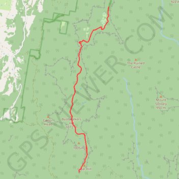
Narrow Neck Trail
Blue Mountains National Park. #Hike #MTB #Loop #NarrowNeck #BlueMountains
- Distance: 12.8 mi
- Elevation gain: 2,454 ft
- Maximum elevation: 3,491 ft
- Elevation loss: 2,454 ft
- Minimum elevation: 2,802 ft
Interactive map
GPS track profile
About this GPS track
Name: Narrow Neck Trail GPS track, route, trail
Start: Glenraphael Drive, Blue Mountains City Council, New South Wales, Australia (-33.74060 150.28021)
End: Glenraphael Drive, Blue Mountains City Council, New South Wales, Australia (-33.74061 150.28021)
Coordinates: -33.81231 150.26014 -33.74060 150.28021
Other GPS tracks
Click on a GPS track to view route, its statistics and profile.
Six Foot Track
Australia > New South Wales > Sydney > Katoomba
Hike / Bike. Kanagra-Boyd National Park. #Hike #Bike #KanagraBoyd
Distance: 27.9 mi • Elevation gain: 5,194 ft • Maximum elevation: 3,957 ft
Perth to Sydney
Australie > Australie occidentale > City of Belmont
Distance: 2,362.0 mi • Elevation gain: 47,762 ft • Maximum elevation: 3,802 ft