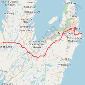
Whitbourne - St. John's
#Bike #Whitbourne #StJohns #Newfoundland #Atlantic
- Distance: 64.2 mi
- Elevation gain: 4,035 ft
- Maximum elevation: 768 ft
- Elevation loss: 4,009 ft
- Minimum elevation: 0 ft
Interactive map
GPS track profile
About this GPS track
Name: Whitbourne - St. John's GPS track, route, trail
End: Cape Spear Path, St. John's, Newfoundland, Newfoundland and Labrador, Canada (47.51998 -52.62413)
Coordinates: 47.32630 -53.55229 47.57163 -52.62413
Other GPS tracks
Click on a GPS track to view route, its statistics and profile.
East Coast Trail - Spout Path
Canada > Newfoundland and Labrador > St. John's
Distance: 13.7 mi • Elevation gain: 2,802 ft • Maximum elevation: 591 ft
St. Johns - Signal Hill - Quidi Vidi
Canada > Newfoundland and Labrador > St. John's
Signal Hill National Historic Site. #Hike #SignalHill #Atlantic
Distance: 3.7 mi • Elevation gain: 932 ft • Maximum elevation: 489 ft
Argentia - Whitbourne
Canada > Newfoundland and Labrador > Placentia
Distance: 28.5 mi • Elevation gain: 1,486 ft • Maximum elevation: 600 ft
East Coast Trail - Deadmans Bay Path
Canada > Newfoundland and Labrador > St. John's
Distance: 6.2 mi • Elevation gain: 1,444 ft • Maximum elevation: 722 ft
East Coast Trail - Cape Spear Path
Canada > Newfoundland and Labrador > Petty Harbour-Maddox Cove
Distance: 6.8 mi • Elevation gain: 945 ft • Maximum elevation: 292 ft
Arnold's Cove - Whitbourne
Canada > Newfoundland and Labrador
#Bike #ArnoldsCove #Whitbourne #Newfoundland
Distance: 31.4 mi • Elevation gain: 2,359 ft • Maximum elevation: 653 ft