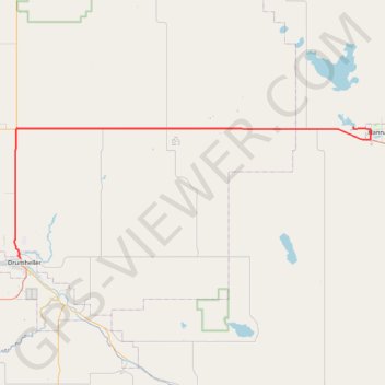
Drumheller - Hanna
#Bike #Drumheller #Hanna
- Distance: 48.9 mi
- Elevation gain: 1,440 ft
- Maximum elevation: 2,999 ft
- Elevation loss: 1,017 ft
- Minimum elevation: 2,244 ft
Interactive map
GPS track profile
About this GPS track
Name: Drumheller - Hanna GPS track, route, trail
End: Township Road 312, Division No. 4, Alberta, Canada (51.65198 -111.97966)
Coordinates: 51.47146 -112.72569 51.65198 -111.94204
Other GPS tracks
Click on a GPS track to view route, its statistics and profile.