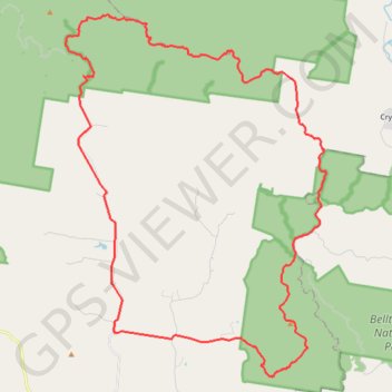
Mount Kilcoy Loop
Bellthorpe National Park. Conondale National Park. #MTB #Loop #Bellthorpe #Conondale
- Distance: 36.3 mi
- Elevation gain: 4,879 ft
- Maximum elevation: 2,352 ft
- Elevation loss: 4,879 ft
- Minimum elevation: 410 ft
Interactive map
GPS track profile
About this GPS track
Name: Mount Kilcoy Loop GPS track, route, trail
Start: Jenkinson Road, Mount Kilcoy, Somerset Regional, Queensland, 4515, Australia (-26.87348 152.58678)
End: Jenkinson Road, Mount Kilcoy, Somerset Regional, Queensland, 4515, Australia (-26.87345 152.58672)
Coordinates: -26.89131 152.56436 -26.74626 152.68123
Other GPS tracks
Click on a GPS track to view route, its statistics and profile.
Bellthorpe - Stoney Creek
Australia > Queensland > Bellthorpe
Bellthorpe National Park. #MTB #Loop #Bellthorpe
Distance: 25.4 mi • Elevation gain: 4,216 ft • Maximum elevation: 2,178 ft