Import a GPX file

Whistler Mountain - High Note Trail

#Hike #Loop #Whistler

  • Distance: 3.9 mi
  • Elevation gain: 892 ft
  • Maximum elevation: 7,139 ft
  • Elevation loss: 2,198 ft
  • Minimum elevation: 5,823 ft

Interactive map

GPS track profile

About this GPS track
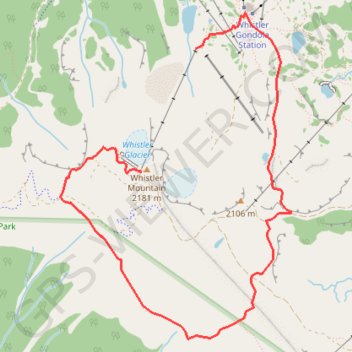
Other GPS tracks

Click on a GPS track to view route, its statistics and profile.

Cheakamus River and Lillooet River

Canada > British Columbia > Squamish-Lillooet Regional District > Area D (Elaho/Garibaldi)

Bikepack from Daisy Lake along Cheakamus River and Lillooet River via Alta Lake, Whistler, Green Lake, Shadow Lake, Nairn Falls, One Mile Lake and Pemberton. #Bike #Nature #River #Lake #Mountain #Forest

Distance: 52.6 mi • Elevation gain: 4,045 ft • Maximum elevation: 2,474 ft

Vancouver - Golden

Canada > British Columbia > Metro Vancouver Regional District > Vancouver

#Bike #Vancouver #Golden

Distance: 514.2 mi • Elevation gain: 30,761 ft • Maximum elevation: 4,419 ft