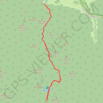
Breadknife - Grand High Tops Track
Warrumbungle National Park. #Hike #Warrumbungle
- Distance: 6.7 mi
- Elevation gain: 1,391 ft
- Maximum elevation: 2,953 ft
- Elevation loss: 1,388 ft
- Minimum elevation: 1,650 ft
- Moving time: 2 h 37 m
- Moving speed: 2.6 mph
- Maximum speed: 9.8 mph
- Total time: 3 h 38 m
- Global speed: 1.8 mph
- Date: 01/23/2020
Interactive map
GPS track profile
About this GPS track
Name: Breadknife - Grand High Tops Track GPS track, route, trail
Start: Fans Horizon trail, Gilgandra Shire Council, New South Wales, Australia (-31.29639 148.99464)
End: Grand High Tops Track, Gilgandra Shire Council, New South Wales, Australia (-31.29656 148.99461)
Coordinates: -31.33124 148.99363 -31.29639 149.00170
Other GPS tracks
Click on a GPS track to view route, its statistics and profile.
Perth to Sydney
Australie > Australie occidentale > City of Belmont
Distance: 2,362.0 mi • Elevation gain: 47,762 ft • Maximum elevation: 3,802 ft