Hélécine
- Distance: 63.9 mi
- Elevation gain: 2,795 ft
- Maximum elevation: 335 ft
- Elevation loss: 2,795 ft
- Minimum elevation: 79 ft
Interactive map
GPS track profile
About this GPS track
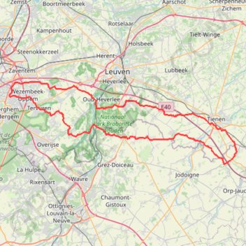
Name: Hélécine GPS track, route, trail
Coordinates: 50.73930 4.44277 50.86331 4.98644
Other GPS tracks
Click on a GPS track to view route, its statistics and profile.
French Divide
France > Hauts-de-France > Nord > Bray-Dunes
Traversez la France du nord au sud sur 2200 Km de sentiers, chemins et petites routes... Magique ! Vous connaissez la mythique Great Divide ? La French Divide est elle aussi en train de devenir une grande classique des traversées en bikepacking et sans assistance !
Distance: 1,376.9 mi • Elevation gain: 110,164 ft • Maximum elevation: 4,754 ft
Rhin par la rive gauche
Suisse > Uri > Korporation Ursern > Andermatt
Vélo. En aller simple entre Andermatt et Hoek van Holland. Suisse centrale. #Vélo #SuisseCentrale #Alpes #Montagne #Nature
Distance: 903.8 mi • Elevation gain: 22,533 ft • Maximum elevation: 6,716 ft
Eurovelo 15 - Entire Route
Pays-Bas > Hollande-Méridionale > Hoek van Holland
Distance: 903.2 mi • Elevation gain: 27,156 ft • Maximum elevation: 6,716 ft
Tour d'Europe
France > Bretagne > Finistère > Concarneau > Landan Creis
Distance: 4,432.2 mi • Elevation gain: 146,335 ft • Maximum elevation: 7,982 ft
J2-01-DA
Belgique > Brabant wallon > Nivelles > Jodoigne
Distance: 4.8 mi • Elevation gain: 249 ft • Maximum elevation: 351 ft
Hageland 21/4
Belgique > Bruxelles-Capitale > Bruxelles
Distance: 62.3 mi • Elevation gain: 2,536 ft • Maximum elevation: 381 ft
Kotk 2024 - Dag 2 - WZ
Belgique > Anvers > Malines > Malines
Distance: 152.6 mi • Elevation gain: 3,025 ft • Maximum elevation: 256 ft
GR5-001-3 GR 5 Belgie, Vlaanderen Zuid
Belgique > Anvers > Anvers > Zoersel
Distance: 114.8 mi • Elevation gain: 3,589 ft • Maximum elevation: 384 ft
Atomium - Tervuren (No roadworks)
Belgique > Bruxelles-Capitale > Mutsaard
Distance: 49.6 mi • Elevation gain: 1,611 ft • Maximum elevation: 325 ft
Gravel 19 - 50 km
Belgique > Brabant flamand > Louvain > Tervuren
Distance: 32.3 mi • Elevation gain: 1,906 ft • Maximum elevation: 463 ft
Auderghem - Oudergem
Belgique > Bruxelles-Capitale > Auderghem
<p>From Avenue du Parc de Woluwe - Park van Woluwelaan 25;27, 1160 Auderghem - Oudergem, Belgium<br/> To Avenue du Parc de Woluwe - Park van Woluwelaan, 1160 Auderghem - Oudergem, Belgium</p> <p>Routing Recreational cycling - shortest</p>
Distance: 55.8 mi • Elevation gain: 1,827 ft • Maximum elevation: 387 ft
Rhin par la rive gauche
Suisse > Uri > Korporation Ursern > Andermatt
Distance: 903.6 mi • Elevation gain: 20,518 ft • Maximum elevation: 6,726 ft
Arquennes
Belgique > Bruxelles-Capitale > Auderghem
<p>From Avenue des Martinets - Steenzwaluwenlaan 25, 1160 Auderghem - Oudergem, Belgium<br/> To Avenue Delleur - Delleurlaan 13, 1170 Boitsfort - Bosvoorde, Belgium</p> <p>Routing Race cycling - shortest</p>
Distance: 61.6 mi • Elevation gain: 3,268 ft • Maximum elevation: 528 ft
TET_B-01-NW_20230301
Pays-Bas > Brabant-Septentrional > Reusel
Distance: 278.3 mi • Elevation gain: 10,413 ft • Maximum elevation: 538 ft
Nord-est de la forêt de Soignes - 25302 - UtagawaVTT.com
Belgique > Bruxelles-Capitale > Auderghem
Distance: 20.3 mi • Elevation gain: 1,175 ft • Maximum elevation: 413 ft
Chateau-Fort de Feluy
Belgique > Bruxelles-Capitale > Bruxelles
Distance: 59.5 mi • Elevation gain: 3,612 ft • Maximum elevation: 541 ft
Stage 14: Frederikshavn to Aars — European Divide Trail
Danemark > Jutland du Nord > Frederikshavn
Distance: 1,382.7 mi • Elevation gain: 94,114 ft • Maximum elevation: 4,557 ft
Josaphat - Tour de Bruxelles - 85km - 779m
Belgique > Bruxelles-Capitale > Schaerbeek
Distance: 52.8 mi • Elevation gain: 2,638 ft • Maximum elevation: 420 ft
Autumn in BW - 95km - 1000D+
Belgique > Bruxelles-Capitale > Bruxelles
Distance: 58.8 mi • Elevation gain: 3,386 ft • Maximum elevation: 538 ft
Eurovelo 15 - Strasbourg Rotterdam
France > Grand Est > Bas-Rhin > Strasbourg
comment ...
Distance: 554.1 mi • Elevation gain: 7,021 ft • Maximum elevation: 479 ft
Bruxelles Anvers
Belgique > Bruxelles-Capitale > Anderlecht > Moortebeek
De mon domicile à la Brasserie De Koninck
Distance: 37.7 mi • Elevation gain: 528 ft • Maximum elevation: 118 ft
Eurovéloroute-15-Route-du-Rhin
Suisse > Uri > Korporation Ursern > Andermatt
Distance: 931.4 mi • Elevation gain: 22,854 ft • Maximum elevation: 6,713 ft
80km Bello Gallico 2022 V1.1
Belgique > Brabant flamand > Louvain > Vieux-Héverlé
Distance: 50.1 mi • Elevation gain: 3,369 ft • Maximum elevation: 351 ft
A Travers Le Brabant 2022 - 110km
Belgique > Brabant wallon > Nivelles > Mont-Saint-Guibert
Route created on plotaroute.com
Distance: 69.1 mi • Elevation gain: 3,465 ft • Maximum elevation: 545 ft
Eurovelo 15 - Entire Route
Pays-Bas > Hollande-Méridionale > Hoek van Holland
Distance: 903.5 mi • Elevation gain: 25,433 ft • Maximum elevation: 6,726 ft
Rando Paris-Amsterdam
France > Île-de-France > Paris
Vélo. En aller simple entre Paris et Amsterdam. #Vélo
Distance: 442.2 mi • Elevation gain: 14,229 ft • Maximum elevation: 810 ft
GR128 De RiemSaint à Aachen (Belgique)
Belgique > Brabant flamand > Louvain > Louvain > Kessel-Lo > Bovenlo
Randonnée entre Leuven et Riemst. #Randonnée
Distance: 79.3 mi • Elevation gain: 3,110 ft • Maximum elevation: 413 ft
Morning Ride - Fietsrit - Strava by Stravatogpx app
Belgique > Brabant flamand > Hal-Vilvorde > Hoeilaert
Distance: 43.5 mi • Elevation gain: 3,730 ft • Maximum elevation: 486 ft
Gembloux
Belgique > Province de Namur > Namur > Gembloux
Distance: 58.2 mi • Elevation gain: 1,942 ft • Maximum elevation: 571 ft
Lasne
Belgique > Bruxelles-Capitale > Auderghem
<p>From Avenue Isidore Geyskens - Isidore Geyskenslaan 120, 1160 Auderghem - Oudergem, Belgium<br/> To Avenue Isidore Geyskens - Isidore Geyskenslaan 120, 1160 Auderghem - Oudergem, Belgium</p> <p>Routing Mountain bike - shortest</p>
Distance: 39.2 mi • Elevation gain: 2,625 ft • Maximum elevation: 469 ft
Peutie
Belgique > Bruxelles-Capitale > Auderghem
<p>From Avenue Isidore Geyskens - Isidore Geyskenslaan 136, 1160 Auderghem - Oudergem, Belgium<br/> To Avenue Isidore Geyskens - Isidore Geyskenslaan 136, 1160 Auderghem - Oudergem, Belgium</p> <p>Routing Recreational cycling - shortest</p>
Distance: 32.2 mi • Elevation gain: 879 ft • Maximum elevation: 272 ft
Bercuit A
Belgique > Bruxelles-Capitale > Bruxelles
Distance: 54.6 mi • Elevation gain: 3,150 ft • Maximum elevation: 466 ft
Gravel 19 - 50 km
Belgique > Brabant flamand > Louvain > Tervuren
Distance: 32.3 mi • Elevation gain: 1,719 ft • Maximum elevation: 463 ft
🪨 BBB GRAVEL (15) (S) 56km 770D+ Lasne
Belgique > Bruxelles-Capitale > Bruxelles
Route by James Watson The villages around Lasne may be full of tennis courts, swimming pools and stables, but its the fantastic off-road riding that we think is the real highlight. This ride is a long one, with some more technical sections making it more challenging but also rewarding.
Distance: 34.7 mi • Elevation gain: 2,484 ft • Maximum elevation: 472 ft
BHCC 2022 #8 Bercuit-Chaumont Gistoux (Short) (E) 67km 700D+
Belgique > Bruxelles-Capitale > Bruxelles
With just 3 rounds to go, including the 'live' finale on Rue du Mystere, the action in the Brussels Hill Climb Challenge is hotting up. Last week we saw a fantastic 75 BBB members register a time up Bruyere du Wez, with congratulations to Dominique Rongvaux on becoming the new KOM on the climb after smashing the 8 year old record.…
Distance: 41.6 mi • Elevation gain: 2,671 ft • Maximum elevation: 433 ft
Bercuit B tourer
Belgique > Bruxelles-Capitale > Bruxelles
Distance: 37.7 mi • Elevation gain: 2,569 ft • Maximum elevation: 440 ft
🪨 BBB GRAVEL (8) (SE) 52km 680D+ E411 Tombeek (gravel variation)
Belgique > Bruxelles-Capitale > Bruxelles
(E411) Tombeek We've named this week's gravel route with a nod to the cobbled classic E3 Harelbeek, due to it also following the direction of a motorway, but the ride is very much in Brabantse Pijl country. With the outward and return routes often close to each other, there are also plenty of options to shorten the ride and add your…
Distance: 32.4 mi • Elevation gain: 2,149 ft • Maximum elevation: 440 ft
Ohain
Belgique > Bruxelles-Capitale > Auderghem
<p>From Avenue des Mésanges - Mezenlaan 11, 1160 Auderghem - Oudergem, Belgium<br/> To Drève Pittoresque - Schilderachtige Dreef 1, 1180 Uccle - Ukkel, Belgium</p> <p>Routing Race cycling - shortest</p>
Distance: 38.5 mi • Elevation gain: 2,231 ft • Maximum elevation: 479 ft
GR128 De Leuven (Belgique) à Maastricht (Pays-Bas)
Belgique > Brabant flamand > Louvain > Louvain > Héverlé
Randonnée entre Louvain et Maastricht. #Randonnée
Distance: 84.8 mi • Elevation gain: 3,304 ft • Maximum elevation: 410 ft
🪨 BBB GRAVEL (20.2) (E) 50km 600D+ Everberg
Belgique > Bruxelles-Capitale > Bruxelles
Route by James Watson, reviewed by Jérôme Grimonpon. This route towards Everberg is generally on good paths, although the short section near the motorway after Sterrebeek is technical at the best of times, and the path through Marnixbox before Jezus-Eik can also get muddy in places.
Distance: 31.3 mi • Elevation gain: 1,949 ft • Maximum elevation: 413 ft
Waterloo
Belgique > Bruxelles-Capitale > Bruxelles
Distance: 31.6 mi • Elevation gain: 1,814 ft • Maximum elevation: 463 ft
Brabant W B 22/10
Belgique > Bruxelles-Capitale > Bruxelles
Distance: 48.1 mi • Elevation gain: 3,153 ft • Maximum elevation: 466 ft