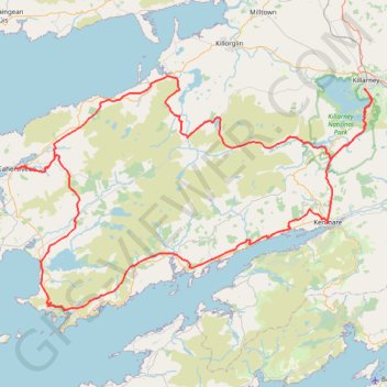
The-kerry-way-entire-trail-walking-route-map-and-guide-kerry-ireland
- Distance: 125.0 mi
- Elevation gain: 16,414 ft
- Maximum elevation: 1,247 ft
- Elevation loss: 16,417 ft
- Minimum elevation: 10 ft
Interactive map
GPS track profile
About this GPS track
Name: The-kerry-way-entire-trail-walking-route-map-and-guide-kerry-ireland GPS track, route, trail
Coordinates: 51.76614 -10.22772 52.06399 -9.49141
Other GPS tracks
Click on a GPS track to view route, its statistics and profile.
Purple Mountain
Distance: 9.6 mi • Elevation gain: 2,825 ft • Maximum elevation: 2,684 ft
Waterville - Derrynane Beach - Caherdaniel
#Hike
Distance: 10.1 mi • Elevation gain: 1,440 ft • Maximum elevation: 797 ft
Trace IRELAND
Distance: 936.2 mi • Elevation gain: 43,829 ft • Maximum elevation: 1,719 ft
RT5-1 Rosslare - Kinsale
Distance: 1,777.3 mi • Elevation gain: 89,833 ft • Maximum elevation: 1,378 ft
RT5-1 Rosslare - Kinsale
Distance: 2,402.9 mi • Elevation gain: 118,488 ft • Maximum elevation: 1,719 ft
RT5-1 Rosslare - Kinsale
Distance: 841.0 mi • Elevation gain: 50,016 ft • Maximum elevation: 1,378 ft