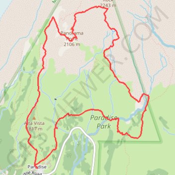
Skyline Trail Loop via Panorama Point and Myrtle Falls
Interactive map
GPS track profile
About this GPS track
Name: Skyline Trail Loop via Panorama Point and Myrtle Falls GPS track, route, trail
Start: Longmire-to-Paradise Road, Paradise, Pierce County, Washington, United States (46.78607 -121.73606)
End: Longmire-to-Paradise Road, Paradise, Pierce County, Washington, United States (46.78610 -121.73604)
Coordinates: 46.78607 -121.73802 46.80620 -121.71575
Topography: Pierce County topographic map
Other GPS tracks
Click on a GPS track to view route, its statistics and profile.
Panorama Point, Golden Gate Falls and Myrtle Falls Loop
United States > Washington > Pierce County > Paradise
Loop hike from Paradise to Panorama Point via Relief Map of Mount Rainier, Skyline Trail, Dead Horse Creek Trail, Glacier Vista Trail, Glacier Vista, Upper Skyline Trail, Golden Gate Trail, Golden Gate Falls and Myrtle Falls Viewpoint in the Mount Rainier National Park and the Paradise Park. #Hike #Loop #Mountain #Nature #Forest…
Distance: 4.7 mi • Elevation gain: 1,759 ft • Maximum elevation: 7,044 ft
Northern part of the Pacific Crest Trail (PCT)
United States > Oregon > Klamath County
Hike on the Pacific Crest National Scenic Trail from Crater Lake to Canada Border through Oregon and Washington along the Sierra Nevada and Cascade mountain ranges. #Hike #Mountain #SierraNevada #Cascade #Nature #Forest #Park #PCT
Distance: 744.6 mi • Elevation gain: 145,367 ft • Maximum elevation: 7,569 ft