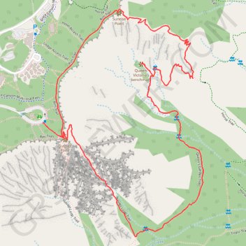
Queen Victoria, Two Bridges and Thor's Hammer Loop
Interactive map
GPS track profile
About this GPS track
Name: Queen Victoria, Two Bridges and Thor's Hammer Loop GPS track, route, trail
Coordinates: 37.61831 -112.16724 37.62839 -112.15826
Topography: Garfield County topographic map
Other GPS tracks
Click on a GPS track to view route, its statistics and profile.
Figure-8 Combination Loop (Bryce Canyon)
United States > Utah > Garfield County
Loop hike in the Bryce Canyon National Park from Sunset Point via Rim Trail, Sunrise Point, Queen's Garden Trail, Tropic Trail, Peekaboo Loop Trail, Peek a Boo Arch, Hindu Temples, The Cathedral, Navajo Loop Trail, Two Bridges and Thor's Hammer. #Hike #Loop #Canyon #Nature #Mountain #Rock #Forest #Park
Distance: 6.4 mi • Elevation gain: 1,640 ft • Maximum elevation: 7,976 ft