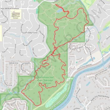
Sope Creek MTB Loop
Mountain Bike loop on Sope Creek Trails in Chattahoochee River National Recreation Area. #MTB #Loop #River #Forest #Nature
- Distance: 6.4 mi
- Elevation gain: 692 ft
- Maximum elevation: 1,027 ft
- Elevation loss: 692 ft
- Minimum elevation: 827 ft
- Moving time: 55 m 24 s
- Moving speed: 7.0 mph
- Maximum speed: 31.5 mph
- Total time: 55 m 24 s
- Global speed: 7.0 mph
- Date: 08/08/2019
Interactive map
GPS track profile
About this GPS track
Name: Sope Creek MTB Loop GPS track, route, trail
Start: Sope Creek, Sibley Forest, Cobb County, Georgia, 30000, United States (33.93787 -84.44253)
End: Sope Creek, Sibley Forest, Cobb County, Georgia, 30000, United States (33.93785 -84.44254)
Coordinates: 33.91601 -84.45136 33.93787 -84.43397
Topography: Cobb County topographic map