4.1 Rev KOTK 2020
- Distance: 40.1 mi
- Elevation gain: 358 ft
- Maximum elevation: 75 ft
- Elevation loss: 354 ft
- Minimum elevation: 0 ft
Interactive map
GPS track profile
About this GPS track
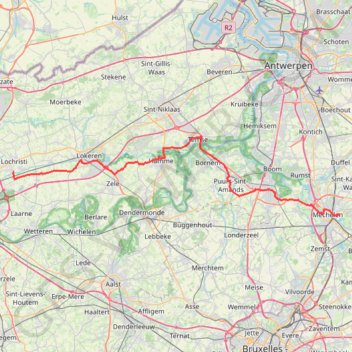
Name: 4.1 Rev KOTK 2020 GPS track, route, trail
Start: N15, Nekkerspoel, Malines, Anvers, Flandre, 2800, Belgique (51.02710 4.49876)
End: 113, Stationsstraat, Lochristi, Gand, Flandre orientale, 9080, Belgique (51.08248 3.83527)
Coordinates: 51.02632 3.83364 51.12900 4.50343
Other GPS tracks
Click on a GPS track to view route, its statistics and profile.
French Divide
France > Hauts-de-France > Nord > Bray-Dunes
Traversez la France du nord au sud sur 2200 Km de sentiers, chemins et petites routes... Magique ! Vous connaissez la mythique Great Divide ? La French Divide est elle aussi en train de devenir une grande classique des traversées en bikepacking et sans assistance !
Distance: 1,376.9 mi • Elevation gain: 110,164 ft • Maximum elevation: 4,754 ft
Rhin par la rive gauche
Suisse > Uri > Korporation Ursern > Andermatt
Vélo. En aller simple entre Andermatt et Hoek van Holland. Suisse centrale. #Vélo #SuisseCentrale #Alpes #Montagne #Nature
Distance: 903.8 mi • Elevation gain: 22,533 ft • Maximum elevation: 6,716 ft
Eurovelo 15 - Entire Route
Pays-Bas > Hollande-Méridionale > Hoek van Holland
Distance: 903.2 mi • Elevation gain: 27,156 ft • Maximum elevation: 6,716 ft
TET_B-01-NW_20230301
Pays-Bas > Brabant-Septentrional > Reusel
Distance: 278.3 mi • Elevation gain: 10,413 ft • Maximum elevation: 538 ft
Rhin par la rive gauche
Suisse > Uri > Korporation Ursern > Andermatt
Distance: 903.6 mi • Elevation gain: 20,518 ft • Maximum elevation: 6,726 ft
Eurovelo 15 - Strasbourg Rotterdam
France > Grand Est > Bas-Rhin > Strasbourg
comment ...
Distance: 554.1 mi • Elevation gain: 7,021 ft • Maximum elevation: 479 ft
Eurovéloroute-15-Route-du-Rhin
Suisse > Uri > Korporation Ursern > Andermatt
Distance: 931.4 mi • Elevation gain: 22,854 ft • Maximum elevation: 6,713 ft
De Bruxelles vers la mer du Nord GR
Belgique > Brabant flamand > Hal-Vilvorde > Merchtem
Randonnée entre Merchtem et Oostende. #Randonnée
Distance: 149.1 mi • Elevation gain: 2,195 ft • Maximum elevation: 233 ft
Bruxelles Anvers
Belgique > Bruxelles-Capitale > Anderlecht > Moortebeek
De mon domicile à la Brasserie De Koninck
Distance: 37.7 mi • Elevation gain: 528 ft • Maximum elevation: 118 ft
Rando Paris-Amsterdam
France > Île-de-France > Paris
Vélo. En aller simple entre Paris et Amsterdam. #Vélo
Distance: 442.2 mi • Elevation gain: 14,229 ft • Maximum elevation: 810 ft
Eurovelo 15 - Entire Route
Pays-Bas > Hollande-Méridionale > Hoek van Holland
Distance: 903.5 mi • Elevation gain: 25,433 ft • Maximum elevation: 6,726 ft
Schelderoute
Distance: 110.4 mi • Elevation gain: 1,821 ft • Maximum elevation: 56 ft
Itinéraire de Hoofdweg 182III, 1057 DD Amsterdam, Pays-Bas à 9 Rue Louguet, 62100 Calais, France
Pays-Bas > Hollande-Septentrionale > Amsterdam
Distance: 221.2 mi • Elevation gain: 2,884 ft • Maximum elevation: 69 ft
GR128 De Roeselare à Dendermonde (Belgique)
Belgique > Flandre-Occidentale > Roulers > Roulers > Rumbeke
Randonnée entre Roeselare et Dendermonde. #Randonnée
Distance: 79.6 mi • Elevation gain: 978 ft • Maximum elevation: 131 ft
Infinity 1er novembre
Pays-Bas > Zélande > Wolphaartsdijk
Distance: 54.4 mi • Elevation gain: 535 ft • Maximum elevation: 62 ft
GR5waypoints
Pays-Bas > Brabant-Septentrional > Berg-op-Zoom
Distance: 107.3 mi • Elevation gain: 945 ft • Maximum elevation: 318 ft
Boire à Gand
Belgique > Bruxelles-Capitale > Anderlecht > Aa
Distance: 87.1 mi • Elevation gain: 3,251 ft • Maximum elevation: 305 ft
Eurovelo 15 - Strasbourg Rotterdam
France > Grand Est > Bas-Rhin > Strasbourg
Distance: 554.1 mi • Elevation gain: 6,903 ft • Maximum elevation: 479 ft
Eurovelo 15 - Entire Route
Pays-Bas > Hollande-Méridionale > Hoek van Holland
Distance: 903.5 mi • Elevation gain: 25,433 ft • Maximum elevation: 6,726 ft
Zwalm-Puyenbroeck-68k
Belgium > East Flanders > Oudenaarde > Zwalm > Sint-Denijs-Boekel
name=Zwalm-Puyenbroeck-68k
Distance: 42.4 mi • Elevation gain: 814 ft • Maximum elevation: 177 ft
Mons - Hannut-Blankenberge
Belgique > Liège > Liège > Flémalle > Mons-lez-Liège
Vélo. En aller simple entre Flémalle et Blankenberge. #Vélo
Distance: 137.7 mi • Elevation gain: 2,182 ft • Maximum elevation: 653 ft
TET_B-01-NW_20230301
Pays-Bas > Brabant-Septentrional > Reusel
Distance: 278.3 mi • Elevation gain: 10,413 ft • Maximum elevation: 538 ft
BBB (A) (N) 96km 300D+ Mechelen
Belgique > Bruxelles-Capitale > Bruxelles
Our rides take a break from climbing this week as we head north to the flatlands and canals around Mechelen. We'll pass under the Verbrande bridge which you might recognise from the posters advertising our Brusseleirs Spring Rando on 24th April. With a gentle breeze forecast from the North East, hopefully we won't have to contend…
Distance: 59.4 mi • Elevation gain: 1,447 ft • Maximum elevation: 377 ft
Anvers - Elewijt
Belgique > Anvers > Anvers > Anvers
<p>De Meir 52A, 2000 Anvers, Belgique<br/> À Robert Schumanlaan, 1982 Elewijt, Belgique</p> <p>Routage Vélo de course - le plus joli</p>
Distance: 25.0 mi • Elevation gain: 246 ft • Maximum elevation: 62 ft
SDB-Moerzeke 46K
Belgium > East Flanders > Oudenaarde > Zwalm > Sint-Denijs-Boekel
name=SDB-Moerzeke 46K
Distance: 29.0 mi • Elevation gain: 564 ft • Maximum elevation: 230 ft
SDB-Moerzeke-60k
Belgium > East Flanders > Oudenaarde > Zwalm > Sint-Denijs-Boekel
name=SDB-Moerzeke-60k
Distance: 37.8 mi • Elevation gain: 751 ft • Maximum elevation: 197 ft
1.1 KOTK 2022
Belgium > Antwerp > Mechelen > Mechelen
Distance: 36.2 mi • Elevation gain: 305 ft • Maximum elevation: 89 ft
4.1 KOTK 2022
Belgique > Anvers > Malines > Malines
Distance: 39.8 mi • Elevation gain: 1,076 ft • Maximum elevation: 282 ft
1.1 Rev KOTK 2022
Belgique > Anvers > Malines > Malines
Distance: 39.5 mi • Elevation gain: 325 ft • Maximum elevation: 85 ft
1.1 KOTK 2022
Belgique > Anvers > Malines > Malines
Distance: 36.2 mi • Elevation gain: 305 ft • Maximum elevation: 89 ft
Iedereen 1000 KOTK OVL noordlus 131km met Iben en Jana (eindresultaat deze wk 469km gefietst, 23K gelopen en 12K gewandeld)
Belgium > East Flanders > Gent > Heusden
Distance: 80.9 mi • Elevation gain: 1,900 ft • Maximum elevation: 266 ft
Hamme Waasmunster Langs Durme - 8 km RT.gpx, Created: 2008-jul-22
Belgium > East Flanders > Dendermonde > Waasmunster
Distance: 4.9 mi • Elevation gain: 49 ft • Maximum elevation: 16 ft
Moerzeke 6,8k
Belgique > Flandre orientale > Termonde > Hamme > Moerzeke
name=Moerzeke 6,8k
Distance: 4.2 mi • Elevation gain: 33 ft • Maximum elevation: 16 ft
Moerzeke 7,5k
Belgique > Flandre orientale > Termonde > Hamme > Moerzeke
name=Moerzeke 7,5k
Distance: 4.7 mi • Elevation gain: 49 ft • Maximum elevation: 16 ft