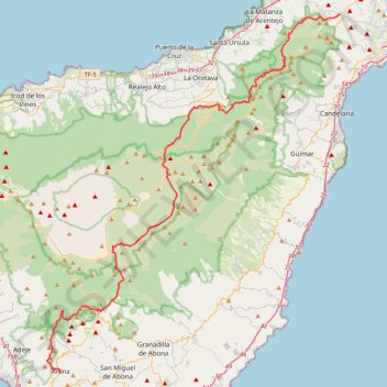
Tenerife (Canary Islands) GR 131
Interactive map
GPS track profile
About this GPS track
Name: Tenerife (Canary Islands) GR 131 GPS track, route, trail
Start: La Esperanza, El Rosario, Santa Cruz de Ténérife, Îles Canaries, Espagne (28.45150 -16.36740)
Coordinates: 28.09820 -16.69650 28.45160 -16.36740
Other GPS tracks
Click on a GPS track to view route, its statistics and profile.
LONG TRAIL GR - 131 TENERIFE (CANARY ISLANDS) GR131 GR 131|trackspotting.com
Spain > El Rosario > La Esperanza
Distance: 54.5 mi • Elevation gain: 14,557 ft • Maximum elevation: 7,887 ft
PicoTeide
Espagne > La Orotava > Portillo Alto
Distance: 5.5 mi • Elevation gain: 4,442 ft • Maximum elevation: 12,136 ft
00 Refugio de Ayosa - Refugio de Las Arenas
Distance: 7.0 mi • Elevation gain: 3,091 ft • Maximum elevation: 6,729 ft
Pico Viejo
Randonnée en aller-retour depuis La Orotava. #Randonnée
Distance: 9.0 mi • Elevation gain: 3,222 ft • Maximum elevation: 10,062 ft
Ten_16_Barranco de Ruiz - San Juan de la Rambla
Espagne > San Juan de la Rambla > La Vera > El Rosario
Distance: 5.3 mi • Elevation gain: 1,736 ft • Maximum elevation: 1,417 ft
Pico Viejo
Distance: 9.0 mi • Elevation gain: 3,225 ft • Maximum elevation: 10,062 ft
Tenerife Las Canadas del Teide - Refuge de Alatvista
Espagne > La Orotava > Portillo Alto
Randonnée depuis La Orotava. #Randonnée
Distance: 4.2 mi • Elevation gain: 2,972 ft • Maximum elevation: 10,702 ft
Roques de Garcia - El Teide
Distance: 3.4 mi • Elevation gain: 833 ft • Maximum elevation: 7,136 ft
Ten_76_Roques de Garcia - Ucanca
Distance: 4.3 mi • Elevation gain: 659 ft • Maximum elevation: 7,136 ft
Refuge Altavista
Espagne > La Orotava > Portillo Alto
Randonnée depuis La Orotava. #Randonnée
Distance: 4.1 mi • Elevation gain: 3,015 ft • Maximum elevation: 10,705 ft
2023-07-07 18:51:02 PICO VIEJO
Distance: 11.8 mi • Elevation gain: 4,423 ft • Maximum elevation: 10,177 ft
Pico del Teide
Espagne > La Orotava > Portillo Alto
Distance: 9.7 mi • Elevation gain: 4,705 ft • Maximum elevation: 12,129 ft
Teide Loop
Espagne > Los Realejos > Portillo Alto
Teide Loop 5h Trail 4, 30, 39, 27, 6, 1
Distance: 13.4 mi • Elevation gain: 1,988 ft • Maximum elevation: 7,936 ft
Ten_78_Paisaje Lunar
Espagne > Vilaflor > Vilaflor de Chasna
Distance: 8.1 mi • Elevation gain: 2,165 ft • Maximum elevation: 6,434 ft
Randonnée du Guadjara (Ténérife)
Distance: 6.7 mi • Elevation gain: 2,408 ft • Maximum elevation: 8,888 ft
Trail Planner Map
Distance: 6.3 mi • Elevation gain: 2,484 ft • Maximum elevation: 8,881 ft