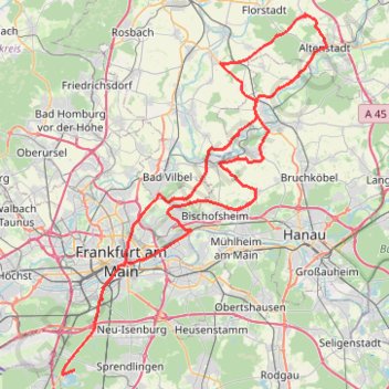
Ironman FFM 2022 Radstrecke
- Distance: 61.2 mi
- Elevation gain: 2,802 ft
- Maximum elevation: 696 ft
- Elevation loss: 2,858 ft
- Minimum elevation: 302 ft
- Moving time: 4 h 12 m
- Moving speed: 14.6 mph
- Maximum speed: 31.3 mph
- Total time: 4 h 12 m
- Global speed: 14.6 mph
- Date: 04/29/2022
Interactive map
GPS track profile
About this GPS track
Name: Ironman FFM 2022 Radstrecke GPS track, route, trail
Start: Sehringstraße, Langen, Landkreis Offenbach, Hesse, 63225, Allemagne (50.02044 8.62261)
Coordinates: 50.01748 8.60686 50.31287 8.94531
Other GPS tracks
Click on a GPS track to view route, its statistics and profile.
Tour d'Europe
France > Bretagne > Finistère > Concarneau > Landan Creis
Distance: 4,432.2 mi • Elevation gain: 146,335 ft • Maximum elevation: 7,982 ft
Eurovelo 15 - Entire Route
Pays-Bas > Hollande-Méridionale > Hoek van Holland
Distance: 903.2 mi • Elevation gain: 27,156 ft • Maximum elevation: 6,716 ft
Rhin par la rive gauche
Suisse > Uri > Korporation Ursern > Andermatt
Vélo. En aller simple entre Andermatt et Hoek van Holland. Suisse centrale. #Vélo #SuisseCentrale #Alpes #Montagne #Nature
Distance: 903.8 mi • Elevation gain: 22,533 ft • Maximum elevation: 6,716 ft
Stage 14: Frederikshavn to Aars — European Divide Trail
Danemark > Jutland du Nord > Frederikshavn
Distance: 1,382.7 mi • Elevation gain: 94,114 ft • Maximum elevation: 4,557 ft
Rhin par la rive gauche
Suisse > Uri > Korporation Ursern > Andermatt
Distance: 903.6 mi • Elevation gain: 20,518 ft • Maximum elevation: 6,726 ft
Eurovéloroute-15-Route-du-Rhin
Suisse > Uri > Korporation Ursern > Andermatt
Distance: 931.4 mi • Elevation gain: 22,854 ft • Maximum elevation: 6,713 ft
Eurovelo 15 - Entire Route
Pays-Bas > Hollande-Méridionale > Hoek van Holland
Distance: 903.5 mi • Elevation gain: 25,433 ft • Maximum elevation: 6,726 ft
E1_Germany 3
Allemagne > Schleswig-Holstein > Schleswig-Flensburg > Oeversee
Distance: 1,179.3 mi • Elevation gain: 108,878 ft • Maximum elevation: 4,744 ft
PT23BS1 Kiel → Lörrach
Germany > Schleswig-Holstein > Kiel
Distance: 650.4 mi • Elevation gain: 30,397 ft • Maximum elevation: 2,484 ft
Marche-en-Famenne
Belgique > Luxembourg > Marche-en-Famenne > Marche-en-Famenne
<p>From Rue Dupont 46, 6900 Marche-en-Famenne, Belgium<br/> To Avenue de France, 6900 Marche-en-Famenne, Belgium</p> <p>Routing Motor - nicest</p>
Distance: 1,766.8 mi • Elevation gain: 94,672 ft • Maximum elevation: 3,537 ft
Eurovelo 15 - Entire Route
Pays-Bas > Hollande-Méridionale > Hoek van Holland
Distance: 903.5 mi • Elevation gain: 25,433 ft • Maximum elevation: 6,726 ft
Track vom: 2020-06-27 07:26
Germany > Bavaria > Landkreis Ostallgäu > Halblech
Distance: 427.6 mi • Elevation gain: 14,131 ft • Maximum elevation: 2,989 ft
Riethoven naar Oostenrijk
Netherlands > North Brabant > Riethoven > Eind
Distance: 573.0 mi • Elevation gain: 44,715 ft • Maximum elevation: 6,224 ft
Track vom: 2020-06-13 07:00
Germany > North Rhine-Westphalia > Kreis Wesel > Schermbeck
Distance: 422.5 mi • Elevation gain: 17,392 ft • Maximum elevation: 3,022 ft
Langener Waldsee
Allemagne > Hesse > Francfort-sur-le-Main
Vélo. En aller simple depuis Frankfurt am Main. #Vélo
Distance: 22.7 mi • Elevation gain: 279 ft • Maximum elevation: 404 ft