Trail Planner Map
- Distance: 2.7 mi
- Elevation gain: 413 ft
- Maximum elevation: 4,357 ft
- Elevation loss: 413 ft
- Minimum elevation: 4,042 ft
Interactive map
GPS track profile
About this GPS track
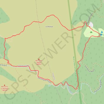
Name: Trail Planner Map GPS track, route, trail
Coordinates: 28.31248 -16.76929 28.32153 -16.75595
Other GPS tracks
Click on a GPS track to view route, its statistics and profile.
Trail Planner Map
Distance: 3.8 mi • Elevation gain: 581 ft • Maximum elevation: 4,321 ft