Singapore Botanical Gardens
- Distance: 6.6 mi
- Elevation gain: 528 ft
- Maximum elevation: 131 ft
- Elevation loss: 525 ft
- Minimum elevation: 13 ft
Interactive map
GPS track profile
About this GPS track
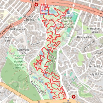
Name: Singapore Botanical Gardens GPS track, route, trail
Start: Cluny Road, Dalvey Villas, Tanglin, Singapore, Central, 258439, Singapore (1.31522 103.81704)
End: Cluny Road, Dalvey Villas, Tanglin, Singapore, Central, 258439, Singapore (1.31555 103.81687)
Coordinates: 1.30694 103.81332 1.32270 103.81912
Other GPS tracks
Click on a GPS track to view route, its statistics and profile.
Singapore Botanical Gardens
Distance: 6.6 mi • Elevation gain: 528 ft • Maximum elevation: 131 ft
The Green Corridor - Singapore
Singapore > Northwest > Singapore
#Hike
Distance: 13.8 mi • Elevation gain: 548 ft • Maximum elevation: 144 ft
Directions from Duck Tour Ramp to Marina Boulevard, Singapore
Singapore > Central > Singapore
Distance: 65.5 mi • Elevation gain: 2,664 ft • Maximum elevation: 167 ft
Singapore Botanical Gardens.gpx
Singapore > Central > Singapore
Distance: 6.6 mi • Elevation gain: 528 ft • Maximum elevation: 131 ft
Kualanamu International Airport to Jakarta, Indonesia
Indonésie > Sumatra du Nord > Deli Serdang > Beringin
Distance: 1,124.2 mi • Elevation gain: 36,014 ft • Maximum elevation: 410 ft