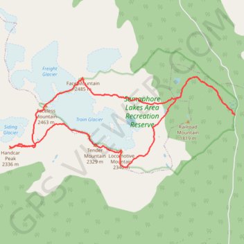
Train-Glacier-5-Peaks-Loop-with-a-Handcar-Mnt-Detour
- Distance: 11.8 mi
- Elevation gain: 7,044 ft
- Maximum elevation: 8,123 ft
- Elevation loss: 7,047 ft
- Minimum elevation: 4,419 ft
Interactive map
GPS track profile
About this GPS track
Name: Train-Glacier-5-Peaks-Loop-with-a-Handcar-Mnt-Detour GPS track, route, trail
Coordinates: 50.57870 -123.09858 50.59927 -123.01769
Other GPS tracks
Click on a GPS track to view route, its statistics and profile.