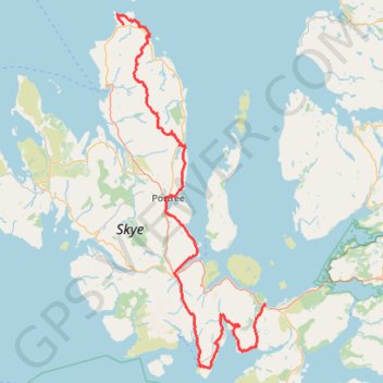
Skye Trail
- Distance: 79.2 mi
- Elevation gain: 12,989 ft
- Maximum elevation: 2,149 ft
- Elevation loss: 13,107 ft
- Minimum elevation: 3 ft
Interactive map
GPS track profile
About this GPS track
Name: Skye Trail GPS track, route, trail
Start: North Duntulm Road, Shulista, Highland, Écosse, IV51 9UG, Royaume-Uni (57.68397 -6.32589)
End: 4, A87, Broadford, Highland, Écosse, IV49 9BF, Royaume-Uni (57.24139 -5.90929)
Coordinates: 57.14208 -6.34477 57.70113 -5.90929
Other GPS tracks
Click on a GPS track to view route, its statistics and profile.
The Old Man of Storr
Royaume-Uni > Écosse > Highland
GPX file from Walkhighlands; file is copyright Walkhighlands and must not be publicly shared on other websites. Do not remove this notice.
Distance: 3.2 mi • Elevation gain: 1,099 ft • Maximum elevation: 1,617 ft
Fairy Pools
Royaume-Uni > Écosse > Highland
Distance: 4.2 mi • Elevation gain: 774 ft • Maximum elevation: 919 ft
Elgol to Camasunary dans les Cuillin
Royaume-Uni > Écosse > Highland > Elgol
Distance: 9.2 mi • Elevation gain: 1,729 ft • Maximum elevation: 620 ft
The Storr - ascent
Royaume-Uni > Écosse > Highland
GPX file from Walkhighlands; file is copyright Walkhighlands and must not be publicly shared on other websites. Do not remove this notice.
Distance: 4.9 mi • Elevation gain: 1,867 ft • Maximum elevation: 2,323 ft
Storr to Portree coast
Royaume-Uni > Écosse > Highland
GPX file from Walkhighlands; file is copyright Walkhighlands and must not be publicly shared on other websites. Do not remove this notice.
Distance: 6.9 mi • Elevation gain: 1,414 ft • Maximum elevation: 1,257 ft
Hebrideanway
Royaume-Uni > Écosse > Na h-Eileanan Siar > Baile Bhatarsaigh
Distance: 200.3 mi • Elevation gain: 13,773 ft • Maximum elevation: 879 ft