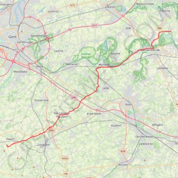
SDB-Moerzeke 46K
name=SDB-Moerzeke 46K
- Distance: 29.0 mi
- Elevation gain: 564 ft
- Maximum elevation: 230 ft
- Elevation loss: 705 ft
- Minimum elevation: 3 ft
Interactive map
GPS track profile
About this GPS track
Name: SDB-Moerzeke 46K GPS track, route, trail
End: 30a, Kasteellaan, Moerzeke, Hamme, Dendermonde, East Flanders, 9220, Belgium (51.06065 4.15599)
Coordinates: 50.86538 3.70992 51.06282 4.15599
Topography: Oudenaarde topographic map
Other GPS tracks
Click on a GPS track to view route, its statistics and profile.
French Divide
France > Hauts-de-France > Nord > Bray-Dunes
Traversez la France du nord au sud sur 2200 Km de sentiers, chemins et petites routes... Magique ! Vous connaissez la mythique Great Divide ? La French Divide est elle aussi en train de devenir une grande classique des traversées en bikepacking et sans assistance !
Distance: 1,376.9 mi • Elevation gain: 110,164 ft • Maximum elevation: 4,754 ft
Rhin par la rive gauche
Suisse > Uri > Korporation Ursern > Andermatt
Vélo. En aller simple entre Andermatt et Hoek van Holland. Suisse centrale. #Vélo #SuisseCentrale #Alpes #Montagne #Nature
Distance: 903.8 mi • Elevation gain: 22,533 ft • Maximum elevation: 6,716 ft
Tour d'Europe
France > Bretagne > Finistère > Concarneau > Landan Creis
Distance: 4,432.2 mi • Elevation gain: 146,335 ft • Maximum elevation: 7,982 ft
Eurovelo 15 - Entire Route
Pays-Bas > Hollande-Méridionale > Hoek van Holland
Distance: 903.2 mi • Elevation gain: 27,156 ft • Maximum elevation: 6,716 ft
Ronde van Vlaanderen fietsroute gele lus
Belgium > East Flanders > Oudenaarde > Oudenaarde
Distance: 63.4 mi • Elevation gain: 2,900 ft • Maximum elevation: 302 ft
NW 14/4
Belgique > Bruxelles-Capitale > Bruxelles
Distance: 61.7 mi • Elevation gain: 2,323 ft • Maximum elevation: 387 ft
TET_B-01-NW_20230301
Pays-Bas > Brabant-Septentrional > Reusel
Distance: 278.3 mi • Elevation gain: 10,413 ft • Maximum elevation: 538 ft
Rhin par la rive gauche
Suisse > Uri > Korporation Ursern > Andermatt
Distance: 903.6 mi • Elevation gain: 20,518 ft • Maximum elevation: 6,726 ft
Vlaamse Ardennen route (TRACK)
Belgique > Flandre orientale > Gand > Deinze > Astene
Distance: 72.4 mi • Elevation gain: 3,986 ft • Maximum elevation: 413 ft
Eurovelo 15 - Strasbourg Rotterdam
France > Grand Est > Bas-Rhin > Strasbourg
comment ...
Distance: 554.1 mi • Elevation gain: 7,021 ft • Maximum elevation: 479 ft
Eurovéloroute-15-Route-du-Rhin
Suisse > Uri > Korporation Ursern > Andermatt
Distance: 931.4 mi • Elevation gain: 22,854 ft • Maximum elevation: 6,713 ft
SDB-Gent-Avelgem
Belgique > Flandre orientale > Audenarde > Zwalin > Boucle-Saint-Denis
name=SDB-Gent-Avelgem
Distance: 61.7 mi • Elevation gain: 988 ft • Maximum elevation: 89 ft
Toerke-78k
Belgium > East Flanders > Oudenaarde > Zwalm > Sint-Denijs-Boekel
name=Toerke-78k
Distance: 48.6 mi • Elevation gain: 1,467 ft • Maximum elevation: 338 ft
De Bruxelles vers la mer du Nord GR
Belgique > Brabant flamand > Hal-Vilvorde > Merchtem
Randonnée entre Merchtem et Oostende. #Randonnée
Distance: 149.1 mi • Elevation gain: 2,195 ft • Maximum elevation: 233 ft
Via Bavay-Velzeke
Belgique > Flandre orientale > Aalst > Velsique-Ruddershove
Randonnée entre Zottegem et Bavay. #Randonnée
Distance: 49.1 mi • Elevation gain: 2,323 ft • Maximum elevation: 453 ft
GR128 De Dendermonde à Leuven (Belgique)
Belgique > Flandre orientale > Termonde > Termonde > Saint-Gilles-lez-Termonde > Boonwijk
Randonnée entre Dendermonde et Louvain. #Randonnée
Distance: 70.9 mi • Elevation gain: 1,857 ft • Maximum elevation: 305 ft
Rando Paris-Amsterdam
France > Île-de-France > Paris
Vélo. En aller simple entre Paris et Amsterdam. #Vélo
Distance: 442.2 mi • Elevation gain: 14,229 ft • Maximum elevation: 810 ft
Eurovelo 15 - Entire Route
Pays-Bas > Hollande-Méridionale > Hoek van Holland
Distance: 903.5 mi • Elevation gain: 25,433 ft • Maximum elevation: 6,726 ft
Schelderoute
Distance: 110.4 mi • Elevation gain: 1,821 ft • Maximum elevation: 56 ft
Itinéraire de Hoofdweg 182III, 1057 DD Amsterdam, Pays-Bas à 9 Rue Louguet, 62100 Calais, France
Pays-Bas > Hollande-Septentrionale > Amsterdam
Distance: 221.2 mi • Elevation gain: 2,884 ft • Maximum elevation: 69 ft
55km
Belgium > East Flanders > Aalst > Nederhasselt
Total: 51.4km
Distance: 31.9 mi • Elevation gain: 1,191 ft • Maximum elevation: 269 ft
GR128 De Roeselare à Dendermonde (Belgique)
Belgique > Flandre-Occidentale > Roulers > Roulers > Rumbeke
Randonnée entre Roeselare et Dendermonde. #Randonnée
Distance: 79.6 mi • Elevation gain: 978 ft • Maximum elevation: 131 ft
1° Dilbeek,SPL,Gooik,OLV Lombeek,Schepdaal,Ternat,SMB,Dilbeek
Belgique > Brabant flamand > Hal-Vilvorde > Dilbeek
Distance: 31.5 mi • Elevation gain: 1,358 ft • Maximum elevation: 305 ft
SDB-Work 32K
Belgium > East Flanders > Oudenaarde > Zwalm > Sint-Denijs-Boekel
name=SDB-Work 32K
Distance: 19.9 mi • Elevation gain: 591 ft • Maximum elevation: 279 ft
GOTOES Export
Belgium > East Flanders > Oudenaarde > Zwalm > Sint-Denijs-Boekel
Created with GOTOES STRAVA TOOLS Version 23.9
Distance: 39.7 mi • Elevation gain: 1,188 ft • Maximum elevation: 279 ft
Boire à Gand
Belgique > Bruxelles-Capitale > Anderlecht > Aa
Distance: 87.1 mi • Elevation gain: 3,251 ft • Maximum elevation: 305 ft
Jan De Lichte
Belgium > East Flanders > Aalst > Strijpen
<p>JAN DE LICHTE.<br/> Gewogen en te lichte bevonden.</p> <p>Een digitale tocht door de Vlaamse Ardennen.<br/> Hij wordt wel eens de Vlaamse Robin Hood genoemd. De lotgevallen van Jan De Lichte en zijn roversbende uit Velzeke werden dan ook literair door Hugo Claus en Louis Paul Boon vereeuwigd. Anton Cogen maakte een scenario voor…
Distance: 7.1 mi • Elevation gain: 413 ft • Maximum elevation: 197 ft
Eurovelo 15 - Strasbourg Rotterdam
France > Grand Est > Bas-Rhin > Strasbourg
Distance: 554.1 mi • Elevation gain: 6,903 ft • Maximum elevation: 479 ft
Eurovelo 15 - Entire Route
Pays-Bas > Hollande-Méridionale > Hoek van Holland
Distance: 903.5 mi • Elevation gain: 25,433 ft • Maximum elevation: 6,726 ft
Zwalm-Puyenbroeck-68k
Belgium > East Flanders > Oudenaarde > Zwalm > Sint-Denijs-Boekel
name=Zwalm-Puyenbroeck-68k
Distance: 42.4 mi • Elevation gain: 814 ft • Maximum elevation: 177 ft
HM Gent2
Belgique > Flandre orientale > Gand > Gand
Distance: 13.4 mi • Elevation gain: 220 ft • Maximum elevation: 46 ft
Mons - Hannut-Blankenberge
Belgique > Liège > Liège > Flémalle > Mons-lez-Liège
Vélo. En aller simple entre Flémalle et Blankenberge. #Vélo
Distance: 137.7 mi • Elevation gain: 2,182 ft • Maximum elevation: 653 ft
Brusseleirs Rando 2023 - 100km
Belgique > Bruxelles-Capitale > Neder-Over-Heembeek
Distance: 62.2 mi • Elevation gain: 2,943 ft • Maximum elevation: 295 ft
Munte-11.3k
Belgique > Flandre orientale > Gand > Merelbeke > Munte
name=Munte-11.3k
Distance: 7.0 mi • Elevation gain: 217 ft • Maximum elevation: 164 ft
GOTOES Export
Belgique > Flandre-Occidentale > Courtrai > Courtrai > Bissegem
Created with GOTOES STRAVA TOOLS Version 20.2
Distance: 91.6 mi • Elevation gain: 1,890 ft • Maximum elevation: 125 ft
De Guirsch à Gendron (définitif) J1
Belgique > Luxembourg > Arlon > Arlon > Guirsch
Distance: 628.8 mi • Elevation gain: 40,561 ft • Maximum elevation: 2,277 ft
TET_B-01-NW_20230301
Pays-Bas > Brabant-Septentrional > Reusel
Distance: 278.3 mi • Elevation gain: 10,413 ft • Maximum elevation: 538 ft
SDB-Beerlegem-12.8
Belgium > East Flanders > Oudenaarde > Zwalm > Sint-Denijs-Boekel
name=SDB-Beerlegem-12.8
Distance: 7.9 mi • Elevation gain: 413 ft • Maximum elevation: 161 ft
De Guirsch à Gendron
Belgique > Luxembourg > Arlon > Arlon > Guirsch
Distance: 613.6 mi • Elevation gain: 41,873 ft • Maximum elevation: 2,277 ft
PARCOURS 21K (versie 23.1)_SGM 2023 - HM
Belgique > Flandre orientale > Gand > Gand
Statistics computed from imported dataMonday, 28 November 2022, 15:42 CETDistance: 21.2 kmDuration: 2 hours, 11 minutes and 4 secondsAverage Speed: 9.7 km/hMinimum Elevation: 1 mMaximum Elevation: 12 mTotal climb: 12 mTotal descent: 11 m
Distance: 13.0 mi • Elevation gain: 259 ft • Maximum elevation: 46 ft
SDB-Moerzeke-60k
Belgium > East Flanders > Oudenaarde > Zwalm > Sint-Denijs-Boekel
name=SDB-Moerzeke-60k
Distance: 37.8 mi • Elevation gain: 751 ft • Maximum elevation: 197 ft
Ronde van Vlaanderen fietsroute gele lus
Belgique > Flandre orientale > Audenarde > Audenarde
Distance: 63.4 mi • Elevation gain: 2,900 ft • Maximum elevation: 302 ft
60k
Belgium > East Flanders > Oudenaarde > Zwalm > Sint-Denijs-Boekel
name=60k
Distance: 37.6 mi • Elevation gain: 1,089 ft • Maximum elevation: 338 ft
Ledeberg-SDB-F45-45k
Belgium > East Flanders > Gent > Ghent > Ledeberg
name=Ledeberg-SDB-F45-45k
Distance: 27.9 mi • Elevation gain: 413 ft • Maximum elevation: 102 ft
4.1 KOTK 2022
Belgique > Anvers > Malines > Malines
Distance: 39.8 mi • Elevation gain: 1,076 ft • Maximum elevation: 282 ft
103 waregem-deinze-oud
Belgium > East Flanders > Oudenaarde > Zwalm > Sint-Denijs-Boekel
name=103 waregem-deinze-oud
Distance: 64.2 mi • Elevation gain: 1,119 ft • Maximum elevation: 213 ft
4.1 Rev KOTK 2020
Belgique > Anvers > Malines > Malines
Distance: 40.1 mi • Elevation gain: 358 ft • Maximum elevation: 75 ft
SDB-Paulatem-10km
Belgium > East Flanders > Oudenaarde > Zwalm > Sint-Denijs-Boekel
name=SDB-Paulatem-10km
Distance: 6.3 mi • Elevation gain: 220 ft • Maximum elevation: 167 ft