Sweet Caro V4
- Distance: 128.5 mi
- Elevation gain: 3,694 ft
- Maximum elevation: 322 ft
- Elevation loss: 3,694 ft
- Minimum elevation: 10 ft
Interactive map
GPS track profile
About this GPS track
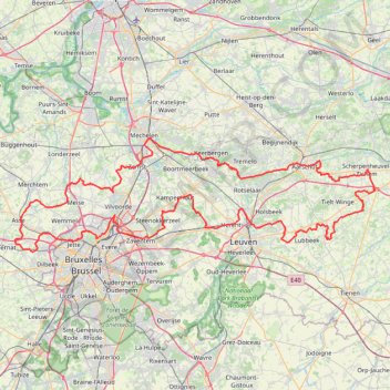
Name: Sweet Caro V4 GPS track, route, trail
Start: 44, Place Cardinal Mercier, Esseghem, Jette, Bruxelles-Capitale, 1090, Belgique (50.88053 4.32974)
Coordinates: 50.86475 4.19424 51.02395 4.99530
Other GPS tracks
Click on a GPS track to view route, its statistics and profile.
French Divide
France > Hauts-de-France > Nord > Bray-Dunes
Traversez la France du nord au sud sur 2200 Km de sentiers, chemins et petites routes... Magique ! Vous connaissez la mythique Great Divide ? La French Divide est elle aussi en train de devenir une grande classique des traversées en bikepacking et sans assistance !
Distance: 1,376.9 mi • Elevation gain: 110,164 ft • Maximum elevation: 4,754 ft
Track
Belgique > Flandre orientale > Aalst > Alost
Distance: 77.2 mi • Elevation gain: 784 ft • Maximum elevation: 125 ft
Rhin par la rive gauche
Suisse > Uri > Korporation Ursern > Andermatt
Vélo. En aller simple entre Andermatt et Hoek van Holland. Suisse centrale. #Vélo #SuisseCentrale #Alpes #Montagne #Nature
Distance: 903.8 mi • Elevation gain: 22,533 ft • Maximum elevation: 6,716 ft
Tour d'Europe
France > Bretagne > Finistère > Concarneau > Landan Creis
Distance: 4,432.2 mi • Elevation gain: 146,335 ft • Maximum elevation: 7,982 ft
Eurovelo 15 - Entire Route
Pays-Bas > Hollande-Méridionale > Hoek van Holland
Distance: 903.2 mi • Elevation gain: 27,156 ft • Maximum elevation: 6,716 ft
2.1 KOTK 2024
Belgium > Antwerp > Mechelen > Mechelen
Distance: 38.3 mi • Elevation gain: 899 ft • Maximum elevation: 220 ft
Kotk 2024 - Dag 2 - WZ
Belgique > Anvers > Malines > Malines
Distance: 152.6 mi • Elevation gain: 3,025 ft • Maximum elevation: 256 ft
Atomium - Tervuren (No roadworks)
Belgique > Bruxelles-Capitale > Mutsaard
Distance: 49.6 mi • Elevation gain: 1,611 ft • Maximum elevation: 325 ft
NW 14/4
Belgique > Bruxelles-Capitale > Bruxelles
Distance: 61.7 mi • Elevation gain: 2,323 ft • Maximum elevation: 387 ft
Auderghem - Oudergem
Belgique > Bruxelles-Capitale > Auderghem
<p>From Avenue du Parc de Woluwe - Park van Woluwelaan 25;27, 1160 Auderghem - Oudergem, Belgium<br/> To Avenue du Parc de Woluwe - Park van Woluwelaan, 1160 Auderghem - Oudergem, Belgium</p> <p>Routing Recreational cycling - shortest</p>
Distance: 55.8 mi • Elevation gain: 1,827 ft • Maximum elevation: 387 ft
GR5-001-3 GR 5 Belgie, Vlaanderen Zuid
Belgique > Anvers > Anvers > Zoersel
Distance: 114.8 mi • Elevation gain: 3,589 ft • Maximum elevation: 384 ft
TET_B-01-NW_20230301
Pays-Bas > Brabant-Septentrional > Reusel
Distance: 278.3 mi • Elevation gain: 10,413 ft • Maximum elevation: 538 ft
Stage 14: Frederikshavn to Aars — European Divide Trail
Danemark > Jutland du Nord > Frederikshavn
Distance: 1,382.7 mi • Elevation gain: 94,114 ft • Maximum elevation: 4,557 ft
Josaphat - Tour de Bruxelles - 85km - 779m
Belgique > Bruxelles-Capitale > Schaerbeek
Distance: 52.8 mi • Elevation gain: 2,638 ft • Maximum elevation: 420 ft
Rhin par la rive gauche
Suisse > Uri > Korporation Ursern > Andermatt
Distance: 903.6 mi • Elevation gain: 20,518 ft • Maximum elevation: 6,726 ft
Eurovelo 15 - Strasbourg Rotterdam
France > Grand Est > Bas-Rhin > Strasbourg
comment ...
Distance: 554.1 mi • Elevation gain: 7,021 ft • Maximum elevation: 479 ft
Eurovéloroute-15-Route-du-Rhin
Suisse > Uri > Korporation Ursern > Andermatt
Distance: 931.4 mi • Elevation gain: 22,854 ft • Maximum elevation: 6,713 ft
Itinéraire de Rue François Vekemans 26, Bruxelles à Avenue des Neuf Provinces 1, Ganshoren
Belgique > Bruxelles-Capitale > Neder-Over-Heembeek
Distance: 6.6 mi • Elevation gain: 279 ft • Maximum elevation: 217 ft
De Bruxelles vers la mer du Nord GR
Belgique > Brabant flamand > Hal-Vilvorde > Merchtem
Randonnée entre Merchtem et Oostende. #Randonnée
Distance: 149.1 mi • Elevation gain: 2,195 ft • Maximum elevation: 233 ft
GR128 De Dendermonde à Leuven (Belgique)
Belgique > Flandre orientale > Termonde > Termonde > Saint-Gilles-lez-Termonde > Boonwijk
Randonnée entre Dendermonde et Louvain. #Randonnée
Distance: 70.9 mi • Elevation gain: 1,857 ft • Maximum elevation: 305 ft
Bruxelles Anvers
Belgique > Bruxelles-Capitale > Anderlecht > Moortebeek
De mon domicile à la Brasserie De Koninck
Distance: 37.7 mi • Elevation gain: 528 ft • Maximum elevation: 118 ft
Rando Paris-Amsterdam
France > Île-de-France > Paris
Vélo. En aller simple entre Paris et Amsterdam. #Vélo
Distance: 442.2 mi • Elevation gain: 14,229 ft • Maximum elevation: 810 ft
GR128 De RiemSaint à Aachen (Belgique)
Belgique > Brabant flamand > Louvain > Louvain > Kessel-Lo > Bovenlo
Randonnée entre Leuven et Riemst. #Randonnée
Distance: 79.3 mi • Elevation gain: 3,110 ft • Maximum elevation: 413 ft
GR126-GR12_Liaison_2020-02-01
Belgique > Bruxelles-Capitale > Jette
Distance: 2.8 mi • Elevation gain: 187 ft • Maximum elevation: 203 ft
Eurovelo 15 - Entire Route
Pays-Bas > Hollande-Méridionale > Hoek van Holland
Distance: 903.5 mi • Elevation gain: 25,433 ft • Maximum elevation: 6,726 ft
Schelderoute
Distance: 110.4 mi • Elevation gain: 1,821 ft • Maximum elevation: 56 ft
Itinéraire de Hoofdweg 182III, 1057 DD Amsterdam, Pays-Bas à 9 Rue Louguet, 62100 Calais, France
Pays-Bas > Hollande-Septentrionale > Amsterdam
Distance: 221.2 mi • Elevation gain: 2,884 ft • Maximum elevation: 69 ft
1° Dilbeek,SPL,Gooik,OLV Lombeek,Schepdaal,Ternat,SMB,Dilbeek
Belgique > Brabant flamand > Hal-Vilvorde > Dilbeek
Distance: 31.5 mi • Elevation gain: 1,358 ft • Maximum elevation: 305 ft
Peutie
Belgique > Bruxelles-Capitale > Auderghem
<p>From Avenue Isidore Geyskens - Isidore Geyskenslaan 136, 1160 Auderghem - Oudergem, Belgium<br/> To Avenue Isidore Geyskens - Isidore Geyskenslaan 136, 1160 Auderghem - Oudergem, Belgium</p> <p>Routing Recreational cycling - shortest</p>
Distance: 32.2 mi • Elevation gain: 879 ft • Maximum elevation: 272 ft
GR128 De Leuven (Belgique) à Maastricht (Pays-Bas)
Belgique > Brabant flamand > Louvain > Louvain > Héverlé
Randonnée entre Louvain et Maastricht. #Randonnée
Distance: 84.8 mi • Elevation gain: 3,304 ft • Maximum elevation: 410 ft
🪨 BBB GRAVEL (20.2) (E) 50km 600D+ Everberg
Belgique > Bruxelles-Capitale > Bruxelles
Route by James Watson, reviewed by Jérôme Grimonpon. This route towards Everberg is generally on good paths, although the short section near the motorway after Sterrebeek is technical at the best of times, and the path through Marnixbox before Jezus-Eik can also get muddy in places.
Distance: 31.3 mi • Elevation gain: 1,949 ft • Maximum elevation: 413 ft
GR5waypoints
Pays-Bas > Brabant-Septentrional > Berg-op-Zoom
Distance: 107.3 mi • Elevation gain: 945 ft • Maximum elevation: 318 ft
Boire à Gand
Belgique > Bruxelles-Capitale > Anderlecht > Aa
Distance: 87.1 mi • Elevation gain: 3,251 ft • Maximum elevation: 305 ft
Eurovelo 15 - Strasbourg Rotterdam
France > Grand Est > Bas-Rhin > Strasbourg
Distance: 554.1 mi • Elevation gain: 6,903 ft • Maximum elevation: 479 ft
Eurovelo 15 - Entire Route
Pays-Bas > Hollande-Méridionale > Hoek van Holland
Distance: 903.5 mi • Elevation gain: 25,433 ft • Maximum elevation: 6,726 ft
Auderghem - Oudergem
Belgique > Bruxelles-Capitale > Auderghem
<p>From Avenue Isidore Geyskens - Isidore Geyskenslaan 126, 1160 Auderghem - Oudergem, Belgium<br/> To Avenue Isidore Geyskens - Isidore Geyskenslaan 126, 1160 Auderghem - Oudergem, Belgium</p> <p>Routing Race cycling - shortest</p>
Distance: 53.4 mi • Elevation gain: 2,201 ft • Maximum elevation: 381 ft
Mons - Hannut-Blankenberge
Belgique > Liège > Liège > Flémalle > Mons-lez-Liège
Vélo. En aller simple entre Flémalle et Blankenberge. #Vélo
Distance: 137.7 mi • Elevation gain: 2,182 ft • Maximum elevation: 653 ft
Bruxelles au vert vf
Belgique > Bruxelles-Capitale > Laeken
Distance: 10.0 mi • Elevation gain: 574 ft • Maximum elevation: 226 ft
Brusseleirs Rando 2023 - 100km
Belgique > Bruxelles-Capitale > Neder-Over-Heembeek
Distance: 62.2 mi • Elevation gain: 2,943 ft • Maximum elevation: 295 ft
De Guirsch à Gendron (définitif) J1
Belgique > Luxembourg > Arlon > Arlon > Guirsch
Distance: 628.8 mi • Elevation gain: 40,561 ft • Maximum elevation: 2,277 ft
BBB (A) (NE) 102km 675D+ Hageland
Belgique > Bruxelles-Capitale > Bruxelles
Distance: 63.2 mi • Elevation gain: 2,425 ft • Maximum elevation: 374 ft
Leuven
Belgique > Bruxelles-Capitale > Auderghem
<p>From Avenue Isidore Geyskens - Isidore Geyskenslaan 136, 1160 Auderghem - Oudergem, Belgium<br/> To Avenue Isidore Geyskens - Isidore Geyskenslaan 136, 1160 Auderghem - Oudergem, Belgium</p> <p>Routing Race cycling - shortest</p>
Distance: 42.8 mi • Elevation gain: 1,591 ft • Maximum elevation: 377 ft
Sven Nys loop BDC
Belgique > Bruxelles-Capitale > Bruxelles
Distance: 74.2 mi • Elevation gain: 2,963 ft • Maximum elevation: 354 ft
SV1 - Rotselaar - 93.2 km
Belgique > Bruxelles-Capitale > Woluwe-Saint-Lambert
Distance: 57.0 mi • Elevation gain: 1,650 ft • Maximum elevation: 338 ft
TET_B-01-NW_20230301
Pays-Bas > Brabant-Septentrional > Reusel
Distance: 278.3 mi • Elevation gain: 10,413 ft • Maximum elevation: 538 ft
De Guirsch à Gendron
Belgique > Luxembourg > Arlon > Arlon > Guirsch
Distance: 613.6 mi • Elevation gain: 41,873 ft • Maximum elevation: 2,277 ft
BBB (A) (N) 96km 300D+ Mechelen
Belgique > Bruxelles-Capitale > Bruxelles
Our rides take a break from climbing this week as we head north to the flatlands and canals around Mechelen. We'll pass under the Verbrande bridge which you might recognise from the posters advertising our Brusseleirs Spring Rando on 24th April. With a gentle breeze forecast from the North East, hopefully we won't have to contend…
Distance: 59.4 mi • Elevation gain: 1,447 ft • Maximum elevation: 377 ft
PROJECT NATIONALE RIT BNPPF WATERMAEL on GPSies.com
Belgique > Bruxelles-Capitale > Watermael-Boitsfort > Watermael
Distance: 75.1 mi • Elevation gain: 2,520 ft • Maximum elevation: 410 ft