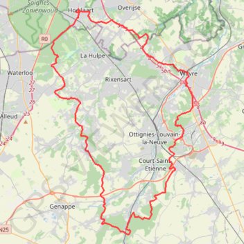
Morning Ride - Fietsrit - Strava by Stravatogpx app
- Distance: 43.5 mi
- Elevation gain: 3,730 ft
- Maximum elevation: 486 ft
- Elevation loss: 3,717 ft
- Minimum elevation: 144 ft
- Moving time: 3 h 54 m
- Moving speed: 11.1 mph
- Maximum speed: 30.2 mph
- Total time: 4 h 22 m
- Global speed: 10.0 mph
- Date: 10/27/2020
Interactive map
GPS track profile
About this GPS track
Name: Morning Ride - Fietsrit - Strava by Stravatogpx app GPS track, route, trail
Start: J.B. Charlierlaan, Hoeilaert, Hal-Vilvorde, Brabant flamand, 1560, Belgique (50.76656 4.47231)
End: 34, Kasteelstraat, Hoeilaert, Hal-Vilvorde, Brabant flamand, 1560, Belgique (50.76620 4.46775)
Coordinates: 50.58811 4.43724 50.76829 4.61577
Other GPS tracks
Click on a GPS track to view route, its statistics and profile.
French Divide
France > Hauts-de-France > Nord > Bray-Dunes
Traversez la France du nord au sud sur 2200 Km de sentiers, chemins et petites routes... Magique ! Vous connaissez la mythique Great Divide ? La French Divide est elle aussi en train de devenir une grande classique des traversées en bikepacking et sans assistance !
Distance: 1,376.9 mi • Elevation gain: 110,164 ft • Maximum elevation: 4,754 ft
GR129-1-2 GR 129 La Belgique en diagonale ! Renaix - Dinant
Belgique > Hainaut > Ath > Ellezelles
Distance: 117.8 mi • Elevation gain: 8,560 ft • Maximum elevation: 906 ft
Rhin par la rive gauche
Suisse > Uri > Korporation Ursern > Andermatt
Vélo. En aller simple entre Andermatt et Hoek van Holland. Suisse centrale. #Vélo #SuisseCentrale #Alpes #Montagne #Nature
Distance: 903.8 mi • Elevation gain: 22,533 ft • Maximum elevation: 6,716 ft
Eurovelo 15 - Entire Route
Pays-Bas > Hollande-Méridionale > Hoek van Holland
Distance: 903.2 mi • Elevation gain: 27,156 ft • Maximum elevation: 6,716 ft
Tour d'Europe
France > Bretagne > Finistère > Concarneau > Landan Creis
Distance: 4,432.2 mi • Elevation gain: 146,335 ft • Maximum elevation: 7,982 ft
GR121
Belgique > Brabant wallon > Nivelles > Wavre
GR121
Distance: 83.4 mi • Elevation gain: 4,682 ft • Maximum elevation: 548 ft
TDH 2024 80
Belgique > Brabant wallon > Nivelles > Court-Saint-Étienne > Tangissart
Distance: 45.2 mi • Elevation gain: 3,904 ft • Maximum elevation: 522 ft
Gravel 19 - 50 km
Belgique > Brabant flamand > Louvain > Tervuren
Distance: 32.3 mi • Elevation gain: 1,906 ft • Maximum elevation: 463 ft
Auderghem - Oudergem
Belgique > Bruxelles-Capitale > Auderghem
<p>From Avenue du Parc de Woluwe - Park van Woluwelaan 25;27, 1160 Auderghem - Oudergem, Belgium<br/> To Avenue du Parc de Woluwe - Park van Woluwelaan, 1160 Auderghem - Oudergem, Belgium</p> <p>Routing Recreational cycling - shortest</p>
Distance: 55.8 mi • Elevation gain: 1,827 ft • Maximum elevation: 387 ft
Rhin par la rive gauche
Suisse > Uri > Korporation Ursern > Andermatt
Distance: 903.6 mi • Elevation gain: 20,518 ft • Maximum elevation: 6,726 ft
Arquennes
Belgique > Bruxelles-Capitale > Auderghem
<p>From Avenue des Martinets - Steenzwaluwenlaan 25, 1160 Auderghem - Oudergem, Belgium<br/> To Avenue Delleur - Delleurlaan 13, 1170 Boitsfort - Bosvoorde, Belgium</p> <p>Routing Race cycling - shortest</p>
Distance: 61.6 mi • Elevation gain: 3,268 ft • Maximum elevation: 528 ft
TET_B-01-NW_20230301
Pays-Bas > Brabant-Septentrional > Reusel
Distance: 278.3 mi • Elevation gain: 10,413 ft • Maximum elevation: 538 ft
Chateau-Fort de Feluy
Belgique > Bruxelles-Capitale > Bruxelles
Distance: 59.5 mi • Elevation gain: 3,612 ft • Maximum elevation: 541 ft
Josaphat - Tour de Bruxelles - 85km - 779m
Belgique > Bruxelles-Capitale > Schaerbeek
Distance: 52.8 mi • Elevation gain: 2,638 ft • Maximum elevation: 420 ft
Autumn in BW - 95km - 1000D+
Belgique > Bruxelles-Capitale > Bruxelles
Distance: 58.8 mi • Elevation gain: 3,386 ft • Maximum elevation: 538 ft
Lille Bruxelles à Vélo
France > Hauts-de-France > Nord > Lille
Vélo. En aller simple entre Lille et Wiltz. #Vélo
Distance: 206.0 mi • Elevation gain: 10,682 ft • Maximum elevation: 1,785 ft
Track-2023_09_30 - Cycle2LiveAgain
Belgique > Brabant wallon > Nivelles > Wavre
Distance: 76.0 mi • Elevation gain: 4,144 ft • Maximum elevation: 699 ft
Eurovelo 15 - Strasbourg Rotterdam
France > Grand Est > Bas-Rhin > Strasbourg
comment ...
Distance: 554.1 mi • Elevation gain: 7,021 ft • Maximum elevation: 479 ft
Lille Nancy J1
France > Hauts-de-France > Nord > Lambersart
Distance: 257.4 mi • Elevation gain: 10,240 ft • Maximum elevation: 1,204 ft
Eurovéloroute-15-Route-du-Rhin
Suisse > Uri > Korporation Ursern > Andermatt
Distance: 931.4 mi • Elevation gain: 22,854 ft • Maximum elevation: 6,713 ft
80km Bello Gallico 2022 V1.1
Belgique > Brabant flamand > Louvain > Vieux-Héverlé
Distance: 50.1 mi • Elevation gain: 3,369 ft • Maximum elevation: 351 ft
Balade à Villers-la-Ville
Belgique > Brabant wallon > Nivelles > Villers-la-Ville
Distance: 5.0 mi • Elevation gain: 515 ft • Maximum elevation: 509 ft
A Travers Le Brabant 2022 - 110km
Belgique > Brabant wallon > Nivelles > Mont-Saint-Guibert
Route created on plotaroute.com
Distance: 69.1 mi • Elevation gain: 3,465 ft • Maximum elevation: 545 ft
Eurovelo 15 - Entire Route
Pays-Bas > Hollande-Méridionale > Hoek van Holland
Distance: 903.5 mi • Elevation gain: 25,433 ft • Maximum elevation: 6,726 ft
Rando Paris-Amsterdam
France > Île-de-France > Paris
Vélo. En aller simple entre Paris et Amsterdam. #Vélo
Distance: 442.2 mi • Elevation gain: 14,229 ft • Maximum elevation: 810 ft
RAB 300 km 2023 - UPDATE 7/5/23
Belgique > Brabant wallon > Nivelles > Braine-l'Alleud
Distance: 191.5 mi • Elevation gain: 13,527 ft • Maximum elevation: 1,329 ft
Sart Messire Guillaume
Belgique > Brabant wallon > Nivelles > Court-Saint-Étienne > Sart-Messire-Guillaume
Distance: 26.7 mi • Elevation gain: 1,532 ft • Maximum elevation: 545 ft
VoyageBelgique
France > Grand Est > Moselle > Metz
Distance: 237.1 mi • Elevation gain: 11,230 ft • Maximum elevation: 1,768 ft
Fosses - Wodecq
Belgique > Province de Namur > Namur > Sambreville
Randonnée entre Fosses-la-Ville et Ellezelles. #Randonnée
Distance: 50.3 mi • Elevation gain: 1,699 ft • Maximum elevation: 594 ft
Lasne
Belgique > Bruxelles-Capitale > Auderghem
<p>From Avenue Isidore Geyskens - Isidore Geyskenslaan 120, 1160 Auderghem - Oudergem, Belgium<br/> To Avenue Isidore Geyskens - Isidore Geyskenslaan 120, 1160 Auderghem - Oudergem, Belgium</p> <p>Routing Mountain bike - shortest</p>
Distance: 39.2 mi • Elevation gain: 2,625 ft • Maximum elevation: 469 ft
Trace Ardennes
France > Hauts-de-France > Nord > Fretin
Distance: 334.2 mi • Elevation gain: 17,844 ft • Maximum elevation: 1,450 ft
Megève - Ohain
France > Auvergne-Rhône-Alpes > Haute-Savoie > Megève
<p>De Route de Rochebrune, 74120 Megève, Auvergne-Rhône-Alpes, France<br/> À Chemin du Moulin, 1380 Ohain, Belgique</p> <p>Routage Moto - le plus joli</p>
Distance: 493.9 mi • Elevation gain: 29,961 ft • Maximum elevation: 4,452 ft
CC24GR lus Longueville
Belgique > Brabant wallon > Nivelles > Chaumont-Gistoux > Le Tri
Distance: 45.5 mi • Elevation gain: 2,234 ft • Maximum elevation: 522 ft
Bercuit A
Belgique > Bruxelles-Capitale > Bruxelles
Distance: 54.6 mi • Elevation gain: 3,150 ft • Maximum elevation: 466 ft
Gravel 19 - 50 km
Belgique > Brabant flamand > Louvain > Tervuren
Distance: 32.3 mi • Elevation gain: 1,719 ft • Maximum elevation: 463 ft
🪨 BBB GRAVEL (15) (S) 56km 770D+ Lasne
Belgique > Bruxelles-Capitale > Bruxelles
Route by James Watson The villages around Lasne may be full of tennis courts, swimming pools and stables, but its the fantastic off-road riding that we think is the real highlight. This ride is a long one, with some more technical sections making it more challenging but also rewarding.
Distance: 34.7 mi • Elevation gain: 2,484 ft • Maximum elevation: 472 ft
BHCC 2022 #8 Bercuit-Chaumont Gistoux (Short) (E) 67km 700D+
Belgique > Bruxelles-Capitale > Bruxelles
With just 3 rounds to go, including the 'live' finale on Rue du Mystere, the action in the Brussels Hill Climb Challenge is hotting up. Last week we saw a fantastic 75 BBB members register a time up Bruyere du Wez, with congratulations to Dominique Rongvaux on becoming the new KOM on the climb after smashing the 8 year old record.…
Distance: 41.6 mi • Elevation gain: 2,671 ft • Maximum elevation: 433 ft
Bercuit B tourer
Belgique > Bruxelles-Capitale > Bruxelles
Distance: 37.7 mi • Elevation gain: 2,569 ft • Maximum elevation: 440 ft
🪨 BBB GRAVEL (8) (SE) 52km 680D+ E411 Tombeek (gravel variation)
Belgique > Bruxelles-Capitale > Bruxelles
(E411) Tombeek We've named this week's gravel route with a nod to the cobbled classic E3 Harelbeek, due to it also following the direction of a motorway, but the ride is very much in Brabantse Pijl country. With the outward and return routes often close to each other, there are also plenty of options to shorten the ride and add your…
Distance: 32.4 mi • Elevation gain: 2,149 ft • Maximum elevation: 440 ft
Ochtendrit
Belgique > Brabant wallon > Nivelles > Incourt
Distance: 49.9 mi • Elevation gain: 2,769 ft • Maximum elevation: 531 ft
Ohain
Belgique > Bruxelles-Capitale > Auderghem
<p>From Avenue des Mésanges - Mezenlaan 11, 1160 Auderghem - Oudergem, Belgium<br/> To Drève Pittoresque - Schilderachtige Dreef 1, 1180 Uccle - Ukkel, Belgium</p> <p>Routing Race cycling - shortest</p>
Distance: 38.5 mi • Elevation gain: 2,231 ft • Maximum elevation: 479 ft