Rota Vicentina - Chemin historique - Étape 1
Santiago do Cacém » Vale Seco
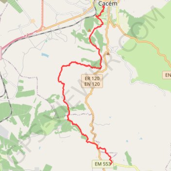
- Distance: 11.0 mi
- Elevation gain: 1,181 ft
- Maximum elevation: 906 ft
- Elevation loss: 1,385 ft
- Minimum elevation: 381 ft
Interactive map
GPS track profile
About this GPS track
Name: Rota Vicentina - Chemin historique - Étape 1 GPS track, route, trail
Coordinates: 37.92251 -8.72996 38.01434 -8.69032
Other GPS tracks
Click on a GPS track to view route, its statistics and profile.
Eurovelo 01 Spain + Portugal
France > Nouvelle-Aquitaine > Pyrénées-Atlantiques > Hendaye
Distance: 1,930.7 mi • Elevation gain: 100,367 ft • Maximum elevation: 4,931 ft
Southern section — European Divide Trail
France > Auvergne-Rhône-Alpes > Drôme > Valence
Distance: 1,506.1 mi • Elevation gain: 139,026 ft • Maximum elevation: 6,578 ft
Stage 26: Valence to Saint-Jean-de-Fos — European Divide Trail
France > Auvergne-Rhône-Alpes > Drôme > Valence
Distance: 1,506.1 mi • Elevation gain: 139,026 ft • Maximum elevation: 6,578 ft
Stage 26: Valence to Saint-Jean-de-Fos — European Divide Trail
Distance: 533.8 mi • Elevation gain: 53,930 ft • Maximum elevation: 4,888 ft