Tambour
- Distance: 1.0 mi
- Elevation gain: 26 ft
- Maximum elevation: 384 ft
- Elevation loss: 253 ft
- Minimum elevation: 148 ft
Interactive map
GPS track profile
About this GPS track
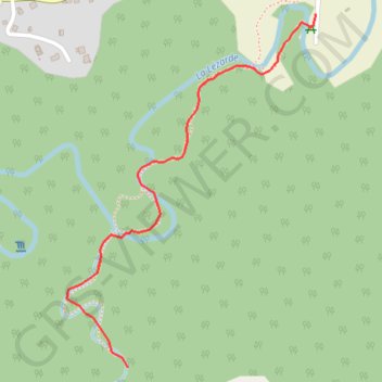
Name: Tambour GPS track, route, trail
Start: Route de Tambour, Petit-Bourg, Basse-Terre, Guadeloupe, 97170, France (16.17877 -61.64309)
Coordinates: 16.17877 -61.64467 16.18746 -61.63829
Other GPS tracks
Click on a GPS track to view route, its statistics and profile.
45 Km
France > Guadeloupe > Lamentin > Crâne
Distance: 28.5 mi • Elevation gain: 2,736 ft • Maximum elevation: 873 ft