Ben Nevis by the Mountain Path
GPX file from Walkhighlands; file is copyright Walkhighlands and must not be publicly shared on other websites. Do not remove this notice.
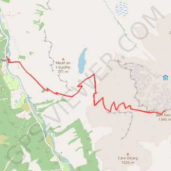
- Distance: 10.0 mi
- Elevation gain: 4,452 ft
- Maximum elevation: 4,386 ft
- Elevation loss: 4,452 ft
- Minimum elevation: 52 ft
Interactive map
GPS track profile
About this GPS track
Name: Ben Nevis by the Mountain Path GPS track, route, trail
Start: Glen Nevis Road, Achintee, Glen Nevis, Highland, Écosse, PH33 6TE, Royaume-Uni (56.81082 -5.07713)
End: Glen Nevis Road, Achintee, Glen Nevis, Highland, Écosse, PH33 6TE, Royaume-Uni (56.81080 -5.07712)
Coordinates: 56.79591 -5.07713 56.81082 -5.00368
Other GPS tracks
Click on a GPS track to view route, its statistics and profile.
Ben Nevis by the Mountain Path
Royaume-Uni > Écosse > Highland > Glen Nevis > Achintee
GPX file from Walkhighlands; file is copyright Walkhighlands and must not be publicly shared on other websites. Do not remove this notice.
Distance: 10.0 mi • Elevation gain: 4,452 ft • Maximum elevation: 4,386 ft