Gmaps Pedometer Route
- Distance: 312.5 mi
- Elevation gain: 13,793 ft
- Maximum elevation: 1,942 ft
- Elevation loss: 12,592 ft
- Minimum elevation: 285 ft
Interactive map
GPS track profile
About this GPS track
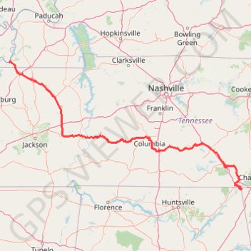
Name: Gmaps Pedometer Route GPS track, route, trail
Start: Hickman Ferry Crossing, Hickman, Fulton County, Kentucky, 42050, United States (36.56821 -89.21210)
End: Dade County, Georgia, United States (34.97154 -85.60281)
Coordinates: 34.96233 -89.21215 36.57345 -85.59426
Topography: Fulton County topographic map
Other GPS tracks
Click on a GPS track to view route, its statistics and profile.
Gravel Route: W Sugar Creek Rd to Gray Branch Rd
United States > Tennessee > Humphreys County > Poplar Grove
Distance: 9.3 mi • Elevation gain: 528 ft • Maximum elevation: 833 ft
Gravel Route: W Sugar Creek Rd to Caney Hollow Rd
United States > Tennessee > Humphreys County
Distance: 4.5 mi • Elevation gain: 289 ft • Maximum elevation: 768 ft