Purple Mountain
- Distance: 9.6 mi
- Elevation gain: 2,825 ft
- Maximum elevation: 2,684 ft
- Elevation loss: 2,822 ft
- Minimum elevation: 164 ft
Interactive map
GPS track profile
About this GPS track
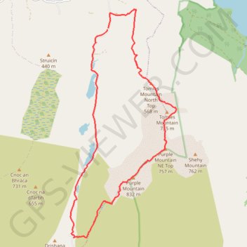
Name: Purple Mountain GPS track, route, trail
Start: Dunloe ED, Kenmare Municipal District, County Kerry, Munster, V93 E029, Ireland (52.04077 -9.63141)
Coordinates: 51.99460 -9.64484 52.04490 -9.60701
Other GPS tracks
Click on a GPS track to view route, its statistics and profile.
The-kerry-way-entire-trail-walking-route-map-and-guide-kerry-ireland
Irlande > Comté de Kerry > Killarney
Distance: 125.0 mi • Elevation gain: 16,414 ft • Maximum elevation: 1,247 ft
Trace IRELAND
Distance: 936.2 mi • Elevation gain: 43,829 ft • Maximum elevation: 1,719 ft
RT5-1 Rosslare - Kinsale
Distance: 1,777.3 mi • Elevation gain: 89,833 ft • Maximum elevation: 1,378 ft
RT5-1 Rosslare - Kinsale
Distance: 2,402.9 mi • Elevation gain: 118,488 ft • Maximum elevation: 1,719 ft
RT5-1 Rosslare - Kinsale
Distance: 841.0 mi • Elevation gain: 50,016 ft • Maximum elevation: 1,378 ft