Scout Lookout
Interactive map
GPS track profile
About this GPS track
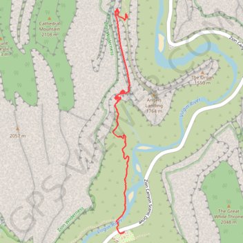
Name: Scout Lookout GPS track, route, trail
Coordinates: 37.25902 -112.95182 37.27566 -112.95025
Topography: Washington County topographic map
Other GPS tracks
Click on a GPS track to view route, its statistics and profile.
Scout Lookout, Emerald Pools, View on the Patriarchs (Zion Canyon)
United States > Utah > Washington County > Zion Lodge
Hike in the Zion Canyon via West Rim Trail, Scout Lookout, Kayenta Trail, Upper Emerald Pool, Lower Emerald Pool, Virgin River, Sand Bench Trail and View on the Patriarchs. #Hike #Canyon #River #Nature #Rock #Mountain #Park #Zion
Distance: 10.3 mi • Elevation gain: 4,629 ft • Maximum elevation: 5,614 ft
Angels Landing and Emerald Pools (Zion Canyon)
United States > Utah > Washington County > Zion Lodge
Hike from West Rim Trailhead to Angels Landing and Emerald Pools via West Rim Trail, Virgin River, Scout Lookout, Kayenta Trail, Lower Emerald Pool, Middle Emerald Pool and Upper Emerald Pool in the Zion National Park. #Hike #Canyon #Zion #Nature #River #Rock #Falls
Distance: 6.9 mi • Elevation gain: 4,216 ft • Maximum elevation: 5,338 ft
Emerald Pools, Scout Lookout and Angels Landing
United States > Utah > Washington County > Zion Lodge
Hike from Zion Lodge to Emerald Pools and Angels Landing via Virgin River, Lower Emerald Pool Trail, Lower Emerald Pool, Upper Emerald Pool, Kayenta Trail, West Rim Trail and Angels Landing Trail in the Zion Canyon and the Zion National Park. #Hike #Canyon #River #Rock #Park #Zion #Nature #Overlook
Distance: 6.0 mi • Elevation gain: 2,861 ft • Maximum elevation: 5,538 ft