Import a GPX file

Mount Willard

Crawford Notch State Park. White Mountain National Forest. #Hike #Moutain #Forest #Lake #Nature

  • Distance: 3.1 mi
  • Elevation gain: 1,014 ft
  • Maximum elevation: 2,782 ft
  • Elevation loss: 1,014 ft
  • Minimum elevation: 1,886 ft

Interactive map

GPS track profile

About this GPS track
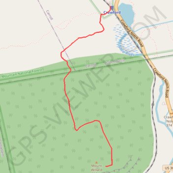
Other GPS tracks

Click on a GPS track to view route, its statistics and profile.

Mount Field, Mount Willey, Mount Avalon and Mount Tom Loop

United States > New Hampshire > Coos County > Carroll

Loop hike from Sako Lake via Avalon Trail, Mount Avalon, Mount Field, Willey Range Trail, Mount Willey, Mount Tom Spur, Mount Tom and A-Z Trail in the White Mountain National Forest. #Hike #Loop #Mountain #Nature #Forest #Lake

Distance: 9.4 mi • Elevation gain: 3,350 ft • Maximum elevation: 4,262 ft

Québec - Montréal - Saint-Laurent River - Lake Ontario - Niagara Falls

Canada > Quebec > Urban agglomeration of Québec > Quebec

#Bike #Ontario

Distance: 670.1 mi • Elevation gain: 15,761 ft • Maximum elevation: 686 ft