Glacier Point and Union Point via Four Mile Trail
Interactive map
GPS track profile
About this GPS track
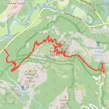
Name: Glacier Point and Union Point via Four Mile Trail GPS track, route, trail
Coordinates: 37.72825 -119.60187 37.73703 -119.57294
Topography: Mariposa County topographic map
Other GPS tracks
Click on a GPS track to view route, its statistics and profile.
Sentinel Dome, Glacier Point, Union Point and Taft Point Loop (Yosemite)
United States > California > Mariposa County
Loop hike from Sentinel Dome Trailhead to Sentinel Dome, Glacier Point, Union Point and Taft Point via Sentinel Dome Trail, Sentinel Dome, Glacier Point, Four Mile Trail, Union Point and Taft Point in the Yosemite National Park. #Hike #Loop #Mountain #Nature #Forest #Yosemite #Park
Distance: 13.3 mi • Elevation gain: 5,827 ft • Maximum elevation: 8,130 ft
Four Mile Trail, Yosemite (Californie)
États-Unis d'Amérique > Californie > Mariposa County > Curry Village
Randonnée pédestre. En aller-retour. #Randonnée
Distance: 10.2 mi • Elevation gain: 5,591 ft • Maximum elevation: 7,208 ft
Walker - Auberry
États-Unis d'Amérique > Californie > Mono County > Walker
Vélo. En aller simple entre Walker et Auberry. #Vélo
Distance: 220.0 mi • Elevation gain: 21,762 ft • Maximum elevation: 9,970 ft