Dream Lake via Nymph Lake
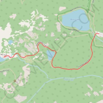
Interactive map
GPS track profile
About this GPS track
Name: Dream Lake via Nymph Lake GPS track, route, trail
Start: Bear Lake Trail, Larimer County, Colorado, United States (40.31194 -105.64562)
End: Bear Lake Road, Larimer County, Colorado, United States (40.31194 -105.64562)
Coordinates: 40.30873 -105.65689 40.31196 -105.64562
Topography: Larimer County topographic map
Other GPS tracks
Click on a GPS track to view route, its statistics and profile.
Bear Lake to Timberline Falls Loop
United States > Colorado > Larimer County
Loop hike from Bear Lake to Timberline Falls via Emerald Lake Trail, Nymph Lake, Dream Lake, Lake Haiyaha, Sky Pond Trail, The Loch, Glacier Gorge Trail and Alberta Falls in the Rocky Mountain National Park. #Hike #Loop #Mountain #Nature #Lake #Forest #Falls #River #Park
Distance: 9.7 mi • Elevation gain: 2,336 ft • Maximum elevation: 10,764 ft