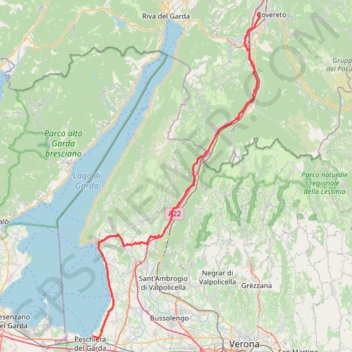
Peschiera Rovereto
Vélo. En aller simple. Vallée de l'Adige. #Vélo #ValléeAdige #Alpes #Montagne #Nature
- Distance: 45.5 mi
- Elevation gain: 2,238 ft
- Maximum elevation: 804 ft
- Elevation loss: 1,890 ft
- Minimum elevation: 223 ft
- Moving time: 4 h 57 m
- Moving speed: 9.2 mph
- Maximum speed: 28.5 mph
- Total time: 6 h 13 m
- Global speed: 7.3 mph
- Date: 05/03/2014
Interactive map
GPS track profile
About this GPS track
Name: Peschiera Rovereto GPS track, route, trail
Coordinates: 45.44549 10.69790 45.88848 11.02216
Other GPS tracks
Click on a GPS track to view route, its statistics and profile.
Eurovelo 6
France > Pays de la Loire > Loire-Atlantique > Saint-Brevin-les-Pins
Distance: 2,815.0 mi • Elevation gain: 59,196 ft • Maximum elevation: 2,808 ft
Tour d'Europe
France > Bretagne > Finistère > Concarneau > Landan Creis
Distance: 4,432.2 mi • Elevation gain: 146,335 ft • Maximum elevation: 7,982 ft
Percorso selezionato
Italie > Lombardie > Côme > Côme
Percorso calcolato con http://www.bicitalia.org/it/routing-gpx
Distance: 959.4 mi • Elevation gain: 58,894 ft • Maximum elevation: 3,392 ft
De Giromagny à Sofia
France > Bourgogne-Franche-Comté > Territoire-de-Belfort > Giromagny
Distance: 1,165.7 mi • Elevation gain: 39,724 ft • Maximum elevation: 3,458 ft
Monte Baldo - Malcesine
Italie > Vénétie > Verona > Malcesine
Randonnée pédestre. En aller simple. Vallée de l'Adige. #Randonnée #ValléeAdige #Alpes #Montagne #Nature
Distance: 6.9 mi • Elevation gain: 331 ft • Maximum elevation: 5,807 ft
Euro 6
France > Pays de la Loire > Loire-Atlantique > Saint-Brevin-les-Pins
Distance: 2,634.6 mi • Elevation gain: 52,064 ft • Maximum elevation: 2,808 ft
Trace
France > Normandie > Seine-Maritime > Saint-Laurent-de-Brèvedent
Distance: 1,334.4 mi • Elevation gain: 77,890 ft • Maximum elevation: 5,308 ft
Trace Alpes 11 jours Août 2022
France > Grand Est > Vosges > Uxegney
Distance: 2,128.7 mi • Elevation gain: 228,714 ft • Maximum elevation: 9,055 ft
2022_DE_Verona-Vicenza | flach
Italy > Veneto > Verona > Verona
Distance: 45.5 mi • Elevation gain: 1,545 ft • Maximum elevation: 522 ft
2022_DE_Peschiera-Verona
Italy > Veneto > Verona > Peschiera del Garda
Distance: 21.1 mi • Elevation gain: 912 ft • Maximum elevation: 623 ft
2022_DE_Trient-Riva del Garda
Italy > Trentino-Alto Adige/Südtirol > Provincia di Trento > Trento
Distance: 31.8 mi • Elevation gain: 1,237 ft • Maximum elevation: 906 ft
Track-E5. ST MORITZ
Italie > Trentin-Haut-Adige > Province de Trente > Madonna di Campiglio > Campo Carlo Magno
Distance: 157.6 mi • Elevation gain: 26,155 ft • Maximum elevation: 7,635 ft
Briançon - Alberville
France > Provence-Alpes-Côte d'Azur > Hautes-Alpes > Briançon > L'Enfer
Briançon - Alberville
Distance: 1,740.5 mi • Elevation gain: 273,993 ft • Maximum elevation: 9,065 ft
NC4K_22_01
Italie > Trentin-Haut-Adige > Province de Trente > Rovereto
Distance: 272.7 mi • Elevation gain: 18,704 ft • Maximum elevation: 5,036 ft
Riva del Garda - Pergine Valsugana
Italy > Trentino-Alto Adige/Südtirol > Provincia di Trento > Riva del Garda > Sant'Alessandro > Alboletta
One-way between Riva del Garda and Pergine Valsugana.
Distance: 120.1 mi • Elevation gain: 18,081 ft • Maximum elevation: 6,686 ft
Isera Trento
Italie > Trentin-Haut-Adige > Province de Trente > Isera
Vélo. En aller simple entre Isera et Trento. Vallée de l'Adige. #Vélo #ValléeAdige #Alpes #Montagne #Nature
Distance: 17.4 mi • Elevation gain: 381 ft • Maximum elevation: 794 ft