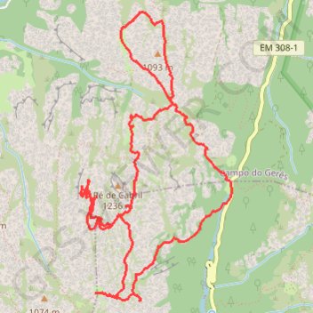
Boucle de 10km de Mata de Albergaria (Geres - Portugal)
Boucle de 10km de Mata de Albergaria (Geres - Portugal)
- Distance: 6.2 mi
- Elevation gain: 1,663 ft
- Maximum elevation: 3,868 ft
- Elevation loss: 1,667 ft
- Minimum elevation: 2,808 ft
- Moving time: 3 h 37 m
- Moving speed: 1.7 mph
- Maximum speed: 3.5 mph
- Total time: 4 h 23 m
- Global speed: 1.4 mph
- Date: 11/27/2016
Interactive map
GPS track profile
About this GPS track
Name: Boucle de 10km de Mata de Albergaria (Geres - Portugal) GPS track, route, trail
Coordinates: 41.75854 -8.16143 41.77941 -8.14680
Other GPS tracks
Click on a GPS track to view route, its statistics and profile.
Eurovelo 01 Spain + Portugal
France > Nouvelle-Aquitaine > Pyrénées-Atlantiques > Hendaye
Distance: 1,930.7 mi • Elevation gain: 100,367 ft • Maximum elevation: 4,931 ft
Volta Nortenha - Maia / Valença / Gerês / Bragança / Mogadou...
Distance: 554.7 mi • Elevation gain: 86,745 ft • Maximum elevation: 4,888 ft
Southern section — European Divide Trail
France > Auvergne-Rhône-Alpes > Drôme > Valence
Distance: 1,506.1 mi • Elevation gain: 139,026 ft • Maximum elevation: 6,578 ft
Stage 26: Valence to Saint-Jean-de-Fos — European Divide Trail
France > Auvergne-Rhône-Alpes > Drôme > Valence
Distance: 1,506.1 mi • Elevation gain: 139,026 ft • Maximum elevation: 6,578 ft
TET_P-1_20231005
Portugal > Vila Real > Montalegre > Tourém
Distance: 249.2 mi • Elevation gain: 38,419 ft • Maximum elevation: 4,216 ft
De Villeneuve-sur-Lot à Guimarães
France > Nouvelle-Aquitaine > Lot-et-Garonne > Villeneuve-sur-Lot
Distance: 1,257.8 mi • Elevation gain: 72,575 ft • Maximum elevation: 4,393 ft