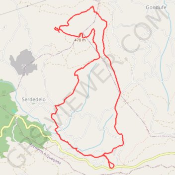
Boucle 10km Castelo da Ermida (Sud-est de Ponte de Lima - Portugal)
Boucle 10km Castelo da Ermida (Sud-est de Ponte de Lima - Portugal)
- Distance: 6.1 mi
- Elevation gain: 1,263 ft
- Maximum elevation: 1,555 ft
- Elevation loss: 1,263 ft
- Minimum elevation: 745 ft
- Moving time: 2 h 57 m
- Moving speed: 2.1 mph
- Maximum speed: 3.2 mph
- Total time: 4 h 10 m
- Global speed: 1.5 mph
- Date: 10/15/2015
Interactive map
GPS track profile
About this GPS track
Name: Boucle 10km Castelo da Ermida (Sud-est de Ponte de Lima - Portugal) GPS track, route, trail
Start: EN 307, Serdedelo, Ponte de Lima, Viana do Castelo, 4990-207, Portugal (41.73905 -8.52207)
End: EN 307, Serdedelo, Ponte de Lima, Viana do Castelo, 4990-207, Portugal (41.73905 -8.52207)
Coordinates: 41.73892 -8.53573 41.76562 -8.51984
Other GPS tracks
Click on a GPS track to view route, its statistics and profile.
Camino Portugues Central
Lissabon - Porto: 347 km<br> Porto - Santiago: 242 km<br><br><a href="https://www.santiago.nl/product-categorie/gidsen/gidsen-portugal/">Gids</a><br>
Distance: 375.5 mi • Elevation gain: 27,198 ft • Maximum elevation: 1,542 ft
Camino Portuguese - Coastal/Monacal
Portugal > Lisbonne > Lisbonne
<p> A route covering the Camino Portuguese - The Portuguese Way, starting from Lisbon to Porto and from there the coastal route.</p> <p> This is a version of the Camino Portuguese names Route Monacal, as it goes along the coast from Porto and does not follow the more common central route.</p> <p> It covers the camino Portuguese from…
Distance: 394.3 mi • Elevation gain: 18,038 ft • Maximum elevation: 1,493 ft
Southern section — European Divide Trail
France > Auvergne-Rhône-Alpes > Drôme > Valence
Distance: 1,506.1 mi • Elevation gain: 139,026 ft • Maximum elevation: 6,578 ft
Eurovelo 01 Spain + Portugal
France > Nouvelle-Aquitaine > Pyrénées-Atlantiques > Hendaye
Distance: 1,930.7 mi • Elevation gain: 100,367 ft • Maximum elevation: 4,931 ft
Volta Nortenha - Maia / Valença / Gerês / Bragança / Mogadou...
Distance: 554.7 mi • Elevation gain: 86,745 ft • Maximum elevation: 4,888 ft
Camino Portugues Central
Portugal > Lisbonne > Lisbonne
Lissabon - Porto: 347 km<br> Porto - Santiago: 242 km<br><br><a href="https://www.santiago.nl/product-categorie/gidsen/gidsen-portugal/">Gids</a><br>
Distance: 375.5 mi • Elevation gain: 27,198 ft • Maximum elevation: 1,542 ft
Stage 26: Valence to Saint-Jean-de-Fos — European Divide Trail
France > Auvergne-Rhône-Alpes > Drôme > Valence
Distance: 1,506.1 mi • Elevation gain: 139,026 ft • Maximum elevation: 6,578 ft
Portugal-santiago-trace-complete
Portugal > Lisbonne > Lisbonne
Distance: 381.7 mi • Elevation gain: 28,540 ft • Maximum elevation: 1,453 ft