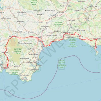
Tour de la petite Manche Angleterre
Vélo. En aller simple entre Plymouth et Weymouth. #Vélo
- Distance: 170.2 mi
- Elevation gain: 13,432 ft
- Maximum elevation: 974 ft
- Elevation loss: 13,294 ft
- Minimum elevation: -3 ft
Interactive map
GPS track profile
About this GPS track
Name: Tour de la petite Manche Angleterre GPS track, route, trail
Coordinates: 50.36324 -4.16009 50.78190 -2.43712
Other GPS tracks
Click on a GPS track to view route, its statistics and profile.
Tour d'Europe
France > Bretagne > Finistère > Concarneau > Landan Creis
Distance: 4,432.2 mi • Elevation gain: 146,335 ft • Maximum elevation: 7,982 ft
Woodland Fort paths
United Kingdom > England > Plymouth
Distance: 3.3 mi • Elevation gain: 318 ft • Maximum elevation: 269 ft
TT22 Jo11 J9/06 : Cheddar à Plymouth Ferry Terminal
Royaume-Uni > Angleterre > Somerset > Cheddar
Distance: 166.7 mi • Elevation gain: 13,681 ft • Maximum elevation: 1,503 ft
21/12/18 Solstice Walk
Royaume-Uni > Angleterre > Dorset > Weymouth > Wyke Regis
Distance: 17.1 mi • Elevation gain: 1,368 ft • Maximum elevation: 525 ft