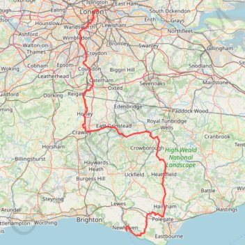
Import a GPX file

Newhaven Londres

Vélo. En aller simple entre Londres et Newhaven. #Vélo

  • Distance: 96.7 mi
  • Elevation gain: 3,737 ft
  • Maximum elevation: 663 ft
  • Elevation loss: 3,848 ft
  • Minimum elevation: 0 ft

Interactive map

GPS track profile

About this GPS track

Other GPS tracks

Click on a GPS track to view route, its statistics and profile.

French Divide

France > Hauts-de-France > Nord > Bray-Dunes

Traversez la France du nord au sud sur 2200 Km de sentiers, chemins et petites routes... Magique ! Vous connaissez la mythique Great Divide ? La French Divide est elle aussi en train de devenir une grande classique des traversées en bikepacking et sans assistance !

Distance: 1,376.9 mi • Elevation gain: 110,164 ft • Maximum elevation: 4,754 ft

London Marathon

United Kingdom > England > London

Distance: 26.2 mi • Elevation gain: 922 ft • Maximum elevation: 164 ft

Paris - Londres à vélo

France > Île-de-France > Paris

Vélo entre Paris et Londres. #Vélo #Paris #Londre

Distance: 263.1 mi • Elevation gain: 7,139 ft • Maximum elevation: 758 ft

Tour d'Europe

France > Bretagne > Finistère > Concarneau > Landan Creis

Distance: 4,432.2 mi • Elevation gain: 146,335 ft • Maximum elevation: 7,982 ft

Crossway Park

United Kingdom > England > London

Morning Run

Distance: 6.0 mi • Elevation gain: 125 ft • Maximum elevation: 72 ft

Lesnes Abbey Woods

United Kingdom > England > London

Morning Walk

Distance: 3.8 mi • Elevation gain: 338 ft • Maximum elevation: 223 ft

Walk - Horsted Keynes, Danehill, Heaven Farm

United Kingdom > England > West Sussex > Mid Sussex

Distance: 8.1 mi • Elevation gain: 925 ft • Maximum elevation: 410 ft

Lesnes Abbey Park

United Kingdom > England > London

Morning Walk

Distance: 4.2 mi • Elevation gain: 289 ft • Maximum elevation: 240 ft

Thamesmead

United Kingdom > England > London

Morning Run

Distance: 4.2 mi • Elevation gain: 79 ft • Maximum elevation: 69 ft

Green Link Walk from Smithfield Market to end at Pekham

United Kingdom > England > City of London

Distance: 5.4 mi • Elevation gain: 135 ft • Maximum elevation: 112 ft

Tour de Londres

Royaume-Uni > Angleterre > Londres

Vélo. En boucle depuis Londres. #Vélo #Boucle

Distance: 46.4 mi • Elevation gain: 971 ft • Maximum elevation: 141 ft

Ardingly Reservoir Loop

United Kingdom > England > West Sussex > Mid Sussex > Balcombe

Loop hike via Balcombe, Braky Wood, Balcombe Lake, Ardingly Reservoir, Ardingly, Wakehurst Place, Mansion Pond, Westwood Lake and The Warren in the High Weald National Landscape. #Hike #Loop #Lake #Nature #Forest #Countryside

Distance: 9.2 mi • Elevation gain: 761 ft • Maximum elevation: 463 ft

Plumstead Parks Loop

United Kingdom > England > London

Loop hike in Plumstead via Winns Common, East Wickham Open Space and Bostall Woods. #Hike #Loop #City #Park #Nature #Forest

Distance: 3.5 mi • Elevation gain: 256 ft • Maximum elevation: 184 ft

Lesnes Abbey Woods and Bostall Woods Loop

United Kingdom > England > London

Loop hike in Abbey Wood and West Eath via Lesnes Abbey Woods and Bostall Woods. #Hike #Loop #City #Nature #Park #Forest

Distance: 3.6 mi • Elevation gain: 325 ft • Maximum elevation: 240 ft

Sutton - East Croydon

United Kingdom > England > London

Walk from Sutton to East Croydon via Beddington Park. #Walk #Hike #City #Nature #Park

Distance: 5.8 mi • Elevation gain: 249 ft • Maximum elevation: 256 ft

Wogebourne Lost River and Woods Loop

United Kingdom > England > London

Loop hike along the Wogebourne River (underground), Bostall Woods, Lesnes Abbey Woods, Abbey Way and Southmere. #Hike #Loop #River #Nature #Forest #Park #Lake

Distance: 4.3 mi • Elevation gain: 259 ft • Maximum elevation: 220 ft

Balcombe to Staplefield Loop

United Kingdom > England > West Sussex > Mid Sussex > Balcombe

Loop hike from Balcombe to Staplefield via Balcombe Recreation Ground, Kemps Farm, Whitethroat Lane, Brantridge Lane, Tanyard Lane, Ditton Place and Westup Road in the High Weald National Landscape. #Hike #Loop #Countryside #Nature #Forest

Distance: 7.7 mi • Elevation gain: 823 ft • Maximum elevation: 463 ft

Regent's Park and Hyde Park Loop

United Kingdom > England > London

Loop hike from Queen's Park to Regent's Park and Hyde Park. #Hike #Loop #City #London #Park #Nature #Lake #Forest

Distance: 9.1 mi • Elevation gain: 384 ft • Maximum elevation: 174 ft

Gravetye Estate Loop

United Kingdom > England > West Sussex > Mid Sussex > West Hoathly > Selsfield Common

Loop hike from Vowels Lane via Warren's Wood, Lower Lake, Hastings Wood, Beeches Shaw, River Medway, Weir Wood Reservoir, Mill Place Farm, Kingscote Shaw, Kingscote Railway Station, Minepit Wood, Mill Place Wood, Bushy Wood and Vowels Gill in the Gravetye Estate and the High Weald National Landscape. #Hike #Loop #Nature #Forest

Distance: 7.9 mi • Elevation gain: 833 ft • Maximum elevation: 489 ft

Bostall Woods to Shrewsbury Park Loop

United Kingdom > England > London

Loop hike from Bostall Woods to Shrewsbury Park via Great Bartletts Woods, Winn Common and Rockliffe Gardens. #Hike #Loop #City #Nature #Park #Forest

Distance: 4.4 mi • Elevation gain: 364 ft • Maximum elevation: 364 ft

Maryon Wilson Park to Thames Barrier Loop

United Kingdom > England > London

Loop hike from Cemetery Lane to Maryon Wilson Park, Maryon Park, Moore Park and Thames Barrier. #Hike #Loop #London #Park #Nature #River #City #Forest

Distance: 3.6 mi • Elevation gain: 292 ft • Maximum elevation: 148 ft

Erith Thames Path

United Kingdom > England > London

Loop hike via Crossness Nature Reserve, River Thames and Frank's Park. #Hike #Loop #Nature #City #River #Park #Forest

Distance: 5.2 mi • Elevation gain: 197 ft • Maximum elevation: 95 ft

Tour de Londres Est Greenwich

Royaume-Uni > Angleterre > Londres

Vélo. En boucle depuis Londres. #Vélo #Boucle

Distance: 19.6 mi • Elevation gain: 801 ft • Maximum elevation: 108 ft

London Marathon

Royaume-Uni > Angleterre > Londres

Distance: 26.2 mi • Elevation gain: 784 ft • Maximum elevation: 161 ft

Mount Caburn

United Kingdom > England > East Sussex > Lewes > Firle > Wick Street

#Bike #Loop

Distance: 31.1 mi • Elevation gain: 3,153 ft • Maximum elevation: 640 ft